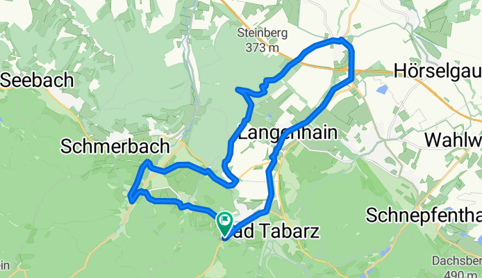
Tabarz - Langenhain - Laucha - Winterstein - Fischbach - Tabarz
A cycling route starting in Tabarz, Free State of Thuringia, Germany.
Overview
About this route
- -:--
- Duration
- 23.6 km
- Distance
- 301 m
- Ascent
- 330 m
- Descent
- ---
- Avg. speed
- 449 m
- Avg. speed
Route quality
Waytypes & surfaces along the route
Waytypes
Track
11.5 km
(49 %)
Busy road
5.1 km
(22 %)
Surfaces
Paved
12.1 km
(52 %)
Unpaved
6.7 km
(28 %)
Asphalt
11 km
(47 %)
Gravel
5.1 km
(22 %)
Continue with Bikemap
Use, edit, or download this cycling route
You would like to ride Tabarz - Langenhain - Laucha - Winterstein - Fischbach - Tabarz or customize it for your own trip? Here is what you can do with this Bikemap route:
Free features
- Save this route as favorite or in collections
- Copy & plan your own version of this route
- Sync your route with Garmin or Wahoo
Premium features
Free trial for 3 days, or one-time payment. More about Bikemap Premium.
- Navigate this route on iOS & Android
- Export a GPX / KML file of this route
- Create your custom printout (try it for free)
- Download this route for offline navigation
Discover more Premium features.
Get Bikemap PremiumFrom our community
Other popular routes starting in Tabarz
- Th. Wald
- Distance
- 99.8 km
- Ascent
- 1,730 m
- Descent
- 1,731 m
- Location
- Tabarz, Free State of Thuringia, Germany
- Tabarz - Gotha - Tabarz
- Distance
- 52.1 km
- Ascent
- 199 m
- Descent
- 315 m
- Location
- Tabarz, Free State of Thuringia, Germany
- urbw07
- Distance
- 86.7 km
- Ascent
- 1,356 m
- Descent
- 1,365 m
- Location
- Tabarz, Free State of Thuringia, Germany
- Fischbach, Tabarz , Torstein, Inselsberg, Fischbach
- Distance
- 15.2 km
- Ascent
- 624 m
- Descent
- 624 m
- Location
- Tabarz, Free State of Thuringia, Germany
- Tabarz - Hörselberge und zurück
- Distance
- 31.2 km
- Ascent
- 549 m
- Descent
- 583 m
- Location
- Tabarz, Free State of Thuringia, Germany
- Inselsbergrunde
- Distance
- 32 km
- Ascent
- 716 m
- Descent
- 718 m
- Location
- Tabarz, Free State of Thuringia, Germany
- Tabarz-Dreiherrenstein-Ruhlaer Skihütte
- Distance
- 30.2 km
- Ascent
- 798 m
- Descent
- 704 m
- Location
- Tabarz, Free State of Thuringia, Germany
- Tabarz - Langenhain - Laucha - Winterstein - Fischbach - Tabarz
- Distance
- 23.6 km
- Ascent
- 301 m
- Descent
- 330 m
- Location
- Tabarz, Free State of Thuringia, Germany
Open it in the app