
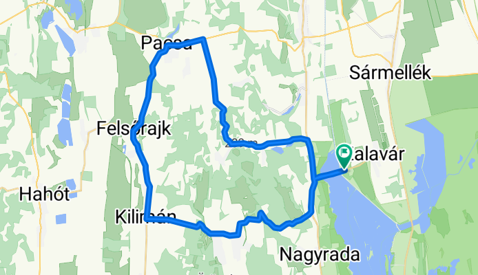
Vársziget út, Zalavár - Vársziget út, Zalavár
A cycling route starting in Sármellék, Zala County, Hungary.
Overview
About this route
- 2 h 26 min
- Duration
- 41.7 km
- Distance
- 399 m
- Ascent
- 398 m
- Descent
- 17.1 km/h
- Avg. speed
- 225 m
- Max. altitude

Route quality
Waytypes & surfaces along the route
Waytypes
Quiet road
0.8 km
(2 %)
Undefined
40.9 km
(98 %)
Surfaces
Paved
10 km
(24 %)
Asphalt
10 km
(24 %)
Undefined
31.7 km
(76 %)
Continue with Bikemap
Use, edit, or download this cycling route
You would like to ride Vársziget út, Zalavár - Vársziget út, Zalavár or customize it for your own trip? Here is what you can do with this Bikemap route:
Free features
- Save this route as favorite or in collections
- Copy & plan your own version of this route
- Sync your route with Garmin or Wahoo
Premium features
Free trial for 3 days, or one-time payment. More about Bikemap Premium.
- Navigate this route on iOS & Android
- Export a GPX / KML file of this route
- Create your custom printout (try it for free)
- Download this route for offline navigation
Discover more Premium features.
Get Bikemap PremiumFrom our community
Other popular routes starting in Sármellék
 Zala utca, Sármellék to József Attila utca, Zalavár
- Distance
- 6.9 km
- Ascent
- 25 m
- Descent
- 35 m
- Location
- Sármellék, Zala County, Hungary
 Balatonmagyaród - Balatonmagyaród
- Distance
- 38.6 km
- Ascent
- 134 m
- Descent
- 135 m
- Location
- Sármellék, Zala County, Hungary
 Zalavár, Kis-Balatoni bemutatóház to Zalavár, Kis-Balatoni bemutatóház
- Distance
- 46.8 km
- Ascent
- 421 m
- Descent
- 421 m
- Location
- Sármellék, Zala County, Hungary
 Zalavár-Kányavári-sziget-Zalakaros-Zalavár
- Distance
- 36.3 km
- Ascent
- 91 m
- Descent
- 90 m
- Location
- Sármellék, Zala County, Hungary
 Petőfi Sándor utca - Petőfi Sándor utca
- Distance
- 41.1 km
- Ascent
- 224 m
- Descent
- 270 m
- Location
- Sármellék, Zala County, Hungary
 Kis Balaton kör
- Distance
- 73.6 km
- Ascent
- 150 m
- Descent
- 153 m
- Location
- Sármellék, Zala County, Hungary
 kisbalaton
- Distance
- 53.7 km
- Ascent
- 219 m
- Descent
- 222 m
- Location
- Sármellék, Zala County, Hungary
 Árpádkori templomrom kanyar a Zala alsó völgyében
- Distance
- 124.8 km
- Ascent
- 382 m
- Descent
- 381 m
- Location
- Sármellék, Zala County, Hungary
Open it in the app