
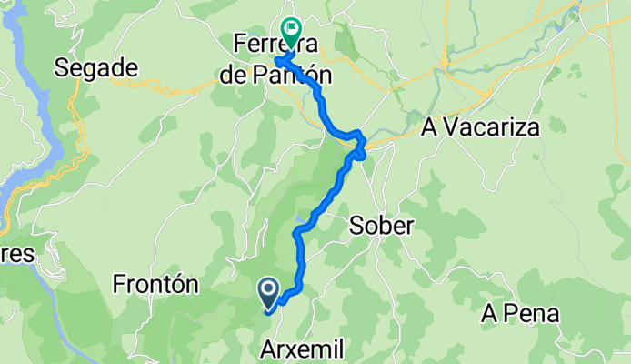
Lugar Nogueira, Sober nach Calle Ourense, Pantón
A cycling route starting in Sober, Galicia, Spain.
Overview
About this route
- 1 h 18 min
- Duration
- 12.7 km
- Distance
- 229 m
- Ascent
- 261 m
- Descent
- 9.8 km/h
- Avg. speed
- 404 m
- Max. altitude
Route photos


Route quality
Waytypes & surfaces along the route
Waytypes
Road
9 km
(71 %)
Quiet road
1.7 km
(13 %)
Undefined
2 km
(16 %)
Continue with Bikemap
Use, edit, or download this cycling route
You would like to ride Lugar Nogueira, Sober nach Calle Ourense, Pantón or customize it for your own trip? Here is what you can do with this Bikemap route:
Free features
- Save this route as favorite or in collections
- Copy & plan your own version of this route
- Sync your route with Garmin or Wahoo
Premium features
Free trial for 3 days, or one-time payment. More about Bikemap Premium.
- Navigate this route on iOS & Android
- Export a GPX / KML file of this route
- Create your custom printout (try it for free)
- Download this route for offline navigation
Discover more Premium features.
Get Bikemap PremiumFrom our community
Other popular routes starting in Sober
 ;irador de Ferrón
- Distance
- 2.4 km
- Ascent
- 113 m
- Descent
- 17 m
- Location
- Sober, Galicia, Spain
 SOBER A MANZANEDA
- Distance
- 90.8 km
- Ascent
- 1,913 m
- Descent
- 817 m
- Location
- Sober, Galicia, Spain
 Sober
Sober- Distance
- 2.4 km
- Ascent
- 55 m
- Descent
- 54 m
- Location
- Sober, Galicia, Spain
- Lugar Nogueira, Sober nach Calle Ourense, Pantón
- Distance
- 12.7 km
- Ascent
- 229 m
- Descent
- 261 m
- Location
- Sober, Galicia, Spain
 Ruta Anllo I
- Distance
- 11.9 km
- Ascent
- 249 m
- Descent
- 250 m
- Location
- Sober, Galicia, Spain
 05. Sober / Lago de Sanabria
- Distance
- 188.7 km
- Ascent
- 2,175 m
- Descent
- 1,533 m
- Location
- Sober, Galicia, Spain
 4-12 Aldea-Ponteareas
- Distance
- 131.7 km
- Ascent
- 1,350 m
- Descent
- 1,851 m
- Location
- Sober, Galicia, Spain
 crono
crono- Distance
- 17.2 km
- Ascent
- 196 m
- Descent
- 199 m
- Location
- Sober, Galicia, Spain
Open it in the app