
München - Lazise
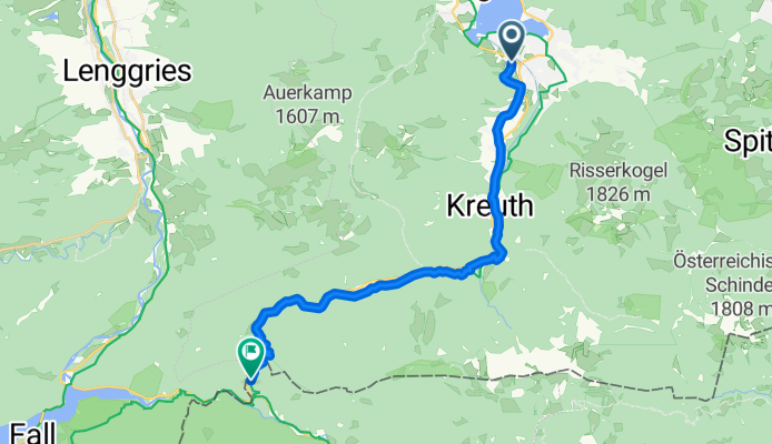
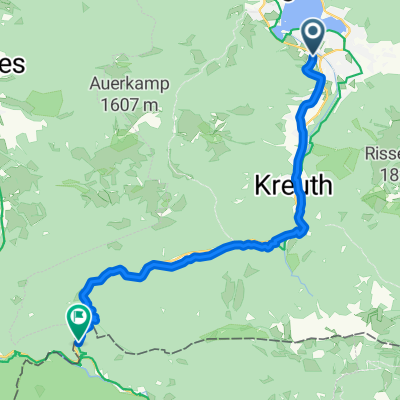
Rottach-Egern - Achenkirch
A cycling route starting in Rottach-Egern, Bavaria, Germany.
Overview
About this route
- 1 h 44 min
- Duration
- 21.1 km
- Distance
- 653 m
- Ascent
- 466 m
- Descent
- 12.1 km/h
- Avg. speed
- 1,001 m
- Max. altitude
Part of
München - Lazise
8 stages
Route quality
Waytypes & surfaces along the route
Waytypes
Track
12 km
(57 %)
Quiet road
3.6 km
(17 %)
Surfaces
Paved
6.8 km
(32 %)
Unpaved
12.2 km
(58 %)
Gravel
7.8 km
(37 %)
Asphalt
5.7 km
(27 %)
Continue with Bikemap
Use, edit, or download this cycling route
You would like to ride Rottach-Egern - Achenkirch or customize it for your own trip? Here is what you can do with this Bikemap route:
Free features
- Save this route as favorite or in collections
- Copy & plan your own version of this route
- Sync your route with Garmin or Wahoo
Premium features
Free trial for 3 days, or one-time payment. More about Bikemap Premium.
- Navigate this route on iOS & Android
- Export a GPX / KML file of this route
- Create your custom printout (try it for free)
- Download this route for offline navigation
Discover more Premium features.
Get Bikemap PremiumFrom our community
Other popular routes starting in Rottach-Egern
 Pfingstrunde
- Distance
- 55.2 km
- Ascent
- 796 m
- Descent
- 798 m
- Location
- Rottach-Egern, Bavaria, Germany
 Tegernsee, Spitzingsee
- Distance
- 31.5 km
- Ascent
- 815 m
- Descent
- 815 m
- Location
- Rottach-Egern, Bavaria, Germany
 Ringberg-MoniAlm-Valepp-Spitzingsee-Schliersee-Ringberg
- Distance
- 56.6 km
- Ascent
- 834 m
- Descent
- 834 m
- Location
- Rottach-Egern, Bavaria, Germany
 Rottach-Egern - Achenkirch
- Distance
- 21.1 km
- Ascent
- 653 m
- Descent
- 466 m
- Location
- Rottach-Egern, Bavaria, Germany
 MTB Festival Tegernseer Tal Strecke B
- Distance
- 55.1 km
- Ascent
- 1,633 m
- Descent
- 1,599 m
- Location
- Rottach-Egern, Bavaria, Germany
 Niklasreut - Spitzingsattel - Valepp
- Distance
- 70.9 km
- Ascent
- 1,047 m
- Descent
- 844 m
- Location
- Rottach-Egern, Bavaria, Germany
 Tegernsee nach Venecia
- Distance
- 525.6 km
- Ascent
- 1,360 m
- Descent
- 2,094 m
- Location
- Rottach-Egern, Bavaria, Germany
 Große Tegernsee Südrunde
- Distance
- 70.8 km
- Ascent
- 1,874 m
- Descent
- 1,873 m
- Location
- Rottach-Egern, Bavaria, Germany
Open it in the app