

Vogesen (Mont Ste.Odile - St.Dié-des-Vosges)
A cycling route starting in Ottrott, Grand Est, France.
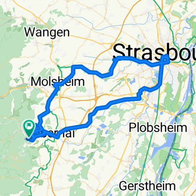
Overview
About this route
Von Mt.Sainte Odile über Champs du Feu - Col de Steige - le Climont - nach St.Dié-des-Vosges
- -:--
- Duration
- 64.8 km
- Distance
- 675 m
- Ascent
- 1,086 m
- Descent
- ---
- Avg. speed
- ---
- Max. altitude

Route highlights
Points of interest along the route
Point of interest after 12.2 km
Hütte GR 5
Continue with Bikemap
Use, edit, or download this cycling route
You would like to ride Vogesen (Mont Ste.Odile - St.Dié-des-Vosges) or customize it for your own trip? Here is what you can do with this Bikemap route:
Free features
- Save this route as favorite or in collections
- Copy & plan your own version of this route
- Sync your route with Garmin or Wahoo
Premium features
Free trial for 3 days, or one-time payment. More about Bikemap Premium.
- Navigate this route on iOS & Android
- Export a GPX / KML file of this route
- Create your custom printout (try it for free)
- Download this route for offline navigation
Discover more Premium features.
Get Bikemap PremiumFrom our community
Other popular routes starting in Ottrott
 BTR 2017
- Distance
- 1,099.4 km
- Ascent
- 5,445 m
- Descent
- 5,562 m
- Location
- Ottrott, Grand Est, France
 70km Klingenthal-Donon
- Distance
- 124.2 km
- Ascent
- 3,038 m
- Descent
- 3,071 m
- Location
- Ottrott, Grand Est, France
 Ottrott-Strasbourg-Ottrott
- Distance
- 89.9 km
- Ascent
- 435 m
- Descent
- 454 m
- Location
- Ottrott, Grand Est, France
 Klingenthal(95km)
- Distance
- 105.6 km
- Ascent
- 2,957 m
- Descent
- 2,868 m
- Location
- Ottrott, Grand Est, France
 Molsheim - Mont Sainte-Odile
- Distance
- 203.9 km
- Ascent
- 3,107 m
- Descent
- 3,675 m
- Location
- Ottrott, Grand Est, France
 Niedermünster Rosheim Mollkirch
- Distance
- 20.3 km
- Ascent
- 255 m
- Descent
- 459 m
- Location
- Ottrott, Grand Est, France
 ottrott 5 sept 10
- Distance
- 50 km
- Ascent
- 1,357 m
- Descent
- 1,348 m
- Location
- Ottrott, Grand Est, France
 Julias Lieblingsrunde
- Distance
- 73.7 km
- Ascent
- 947 m
- Descent
- 947 m
- Location
- Ottrott, Grand Est, France
Open it in the app