
Amsterdam - Düsseldorf
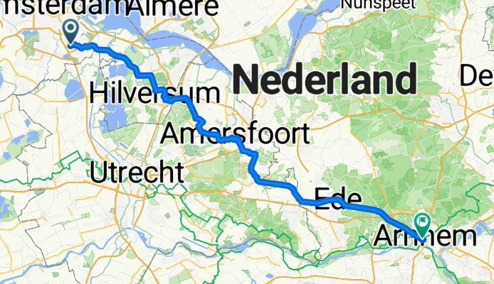
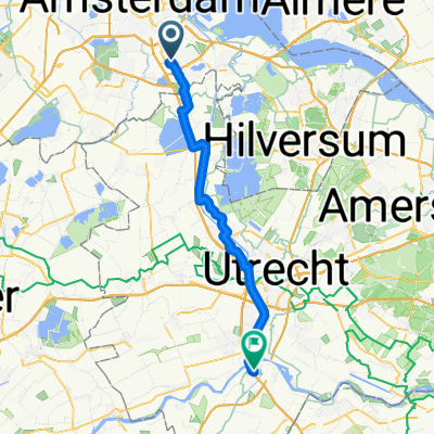
Ede - Goch
A cycling route starting in Amsterdam-Zuidoost, North Holland, The Netherlands.
Overview
About this route
- 5 h 25 min
- Duration
- 94.3 km
- Distance
- 264 m
- Ascent
- 240 m
- Descent
- 17.4 km/h
- Avg. speed
- 78 m
- Max. altitude
Part of
Amsterdam - Düsseldorf
4 stages
Route quality
Waytypes & surfaces along the route
Waytypes
Cycleway
90.5 km
(96 %)
Quiet road
2.8 km
(3 %)
Road
0.9 km
(1 %)
Surfaces
Paved
61.3 km
(65 %)
Asphalt
60.4 km
(64 %)
Paved (undefined)
0.9 km
(1 %)
Undefined
33 km
(35 %)
Continue with Bikemap
Use, edit, or download this cycling route
You would like to ride Ede - Goch or customize it for your own trip? Here is what you can do with this Bikemap route:
Free features
- Save this route as favorite or in collections
- Copy & plan your own version of this route
- Split it into stages to create a multi-day tour
- Sync your route with Garmin or Wahoo
Premium features
Free trial for 3 days, or one-time payment. More about Bikemap Premium.
- Navigate this route on iOS & Android
- Export a GPX / KML file of this route
- Create your custom printout (try it for free)
- Download this route for offline navigation
Discover more Premium features.
Get Bikemap PremiumFrom our community
Other popular routes starting in Amsterdam-Zuidoost
 Hullenbergweg 385, Amsterdam nach Amstel III / Bullewijk, Amsterdam
- Distance
- 76.7 km
- Ascent
- 159 m
- Descent
- 158 m
- Location
- Amsterdam-Zuidoost, North Holland, The Netherlands
 Route to Costa Del Zeumeren
- Distance
- 60.8 km
- Ascent
- 54 m
- Descent
- 37 m
- Location
- Amsterdam-Zuidoost, North Holland, The Netherlands
 Tour 1 Amsterdam
- Distance
- 15.7 km
- Ascent
- 49 m
- Descent
- 48 m
- Location
- Amsterdam-Zuidoost, North Holland, The Netherlands
 Naar Costa Del Zeumeren
- Distance
- 61 km
- Ascent
- 94 m
- Descent
- 77 m
- Location
- Amsterdam-Zuidoost, North Holland, The Netherlands
 Bullewijkpad, Amsterdam nach Haarlemmerstraat 12, Amsterdam
- Distance
- 11.3 km
- Ascent
- 22 m
- Descent
- 18 m
- Location
- Amsterdam-Zuidoost, North Holland, The Netherlands
 Waterlinie-route_370km
- Distance
- 357.5 km
- Ascent
- 0 m
- Descent
- 0 m
- Location
- Amsterdam-Zuidoost, North Holland, The Netherlands
 Johan Cruijff Boulevard, Amsterdã a Prins Bernhardstraat, Vianen
- Distance
- 47.7 km
- Ascent
- 90 m
- Descent
- 91 m
- Location
- Amsterdam-Zuidoost, North Holland, The Netherlands
 Holendrecht - Julianapark Utrecht 30 km
- Distance
- 30.2 km
- Ascent
- 34 m
- Descent
- 28 m
- Location
- Amsterdam-Zuidoost, North Holland, The Netherlands
Open it in the app