
Von Heidelberg bis Wertheim
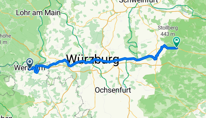
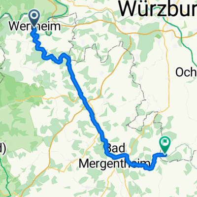
Von Wertheim bis Ebrach
A cycling route starting in Wertheim am Main, Baden-Wurttemberg, Germany.
Overview
About this route
- 5 h 39 min
- Duration
- 93.8 km
- Distance
- 1,302 m
- Ascent
- 1,111 m
- Descent
- 16.6 km/h
- Avg. speed
- 395 m
- Max. altitude

Part of
Von Heidelberg bis Wertheim
3 stages
Route quality
Waytypes & surfaces along the route
Waytypes
Track
31.9 km
(34 %)
Path
25.3 km
(27 %)
Surfaces
Paved
77.9 km
(83 %)
Unpaved
7.5 km
(8 %)
Asphalt
67.5 km
(72 %)
Paved (undefined)
8.4 km
(9 %)
Continue with Bikemap
Use, edit, or download this cycling route
You would like to ride Von Wertheim bis Ebrach or customize it for your own trip? Here is what you can do with this Bikemap route:
Free features
- Save this route as favorite or in collections
- Copy & plan your own version of this route
- Split it into stages to create a multi-day tour
- Sync your route with Garmin or Wahoo
Premium features
Free trial for 3 days, or one-time payment. More about Bikemap Premium.
- Navigate this route on iOS & Android
- Export a GPX / KML file of this route
- Create your custom printout (try it for free)
- Download this route for offline navigation
Discover more Premium features.
Get Bikemap PremiumFrom our community
Other popular routes starting in Wertheim am Main
 Rechte Tauberstraße 1, Wertheim nach Oskar-Popp-Straße 2, Kist
- Distance
- 30.4 km
- Ascent
- 587 m
- Descent
- 357 m
- Location
- Wertheim am Main, Baden-Wurttemberg, Germany
 Wertheim-Obernburg
- Distance
- 57.9 km
- Ascent
- 243 m
- Descent
- 273 m
- Location
- Wertheim am Main, Baden-Wurttemberg, Germany
4169®
Entlang der Tauber...- Distance
- 43.4 km
- Ascent
- 243 m
- Descent
- 240 m
- Location
- Wertheim am Main, Baden-Wurttemberg, Germany
 Von Wertheim bis Tauberrettersheim
- Distance
- 66.7 km
- Ascent
- 1,150 m
- Descent
- 1,059 m
- Location
- Wertheim am Main, Baden-Wurttemberg, Germany
 Schoppenradrundweg
- Distance
- 56.6 km
- Ascent
- 417 m
- Descent
- 417 m
- Location
- Wertheim am Main, Baden-Wurttemberg, Germany
 Von Wertheim bis Ebrach
- Distance
- 93.8 km
- Ascent
- 1,302 m
- Descent
- 1,111 m
- Location
- Wertheim am Main, Baden-Wurttemberg, Germany
 REICHELZE - Laufrunde 1
- Distance
- 8.6 km
- Ascent
- 180 m
- Descent
- 180 m
- Location
- Wertheim am Main, Baden-Wurttemberg, Germany
 Am Grünlingsbaum 28, Wertheim nach Am Grünlingsbaum 28, Wertheim
- Distance
- 20.5 km
- Ascent
- 514 m
- Descent
- 572 m
- Location
- Wertheim am Main, Baden-Wurttemberg, Germany
Open it in the app