
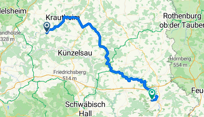
Kocher - Jagst - Radweg 344km
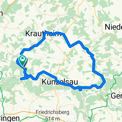
Westernhausen - Crailsheim 72km
A cycling route starting in Weißbach, Baden-Wurttemberg, Germany.
Overview
About this route
- 4 h 19 min
- Duration
- 71.6 km
- Distance
- 1,465 m
- Ascent
- 1,281 m
- Descent
- 16.6 km/h
- Avg. speed
- 440 m
- Max. altitude
Part of
Kocher - Jagst - Radweg 344km
6 stages
Route quality
Waytypes & surfaces along the route
Waytypes
Track
38.6 km
(54 %)
Quiet road
12.9 km
(18 %)
Surfaces
Paved
61.5 km
(86 %)
Unpaved
2.1 km
(3 %)
Asphalt
39.4 km
(55 %)
Paved (undefined)
22.2 km
(31 %)
Continue with Bikemap
Use, edit, or download this cycling route
You would like to ride Westernhausen - Crailsheim 72km or customize it for your own trip? Here is what you can do with this Bikemap route:
Free features
- Save this route as favorite or in collections
- Copy & plan your own version of this route
- Sync your route with Garmin or Wahoo
Premium features
Free trial for 3 days, or one-time payment. More about Bikemap Premium.
- Navigate this route on iOS & Android
- Export a GPX / KML file of this route
- Create your custom printout (try it for free)
- Download this route for offline navigation
Discover more Premium features.
Get Bikemap PremiumFrom our community
Other popular routes starting in Weißbach
 Halberg - Kün - Kupferzell - Kupfer
- Distance
- 46.1 km
- Ascent
- 731 m
- Descent
- 731 m
- Location
- Weißbach, Baden-Wurttemberg, Germany
 Genießertour
- Distance
- 12.9 km
- Ascent
- 279 m
- Descent
- 275 m
- Location
- Weißbach, Baden-Wurttemberg, Germany
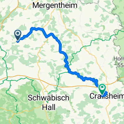
 Ruthardstraße 2, Schöntal nach Bahnhofplatz 2, Bad Mergentheim
- Distance
- 30.8 km
- Ascent
- 323 m
- Descent
- 343 m
- Location
- Weißbach, Baden-Wurttemberg, Germany
 Kocher - Jagst kleine Runde über Sindringen
- Distance
- 37.5 km
- Ascent
- 597 m
- Descent
- 598 m
- Location
- Weißbach, Baden-Wurttemberg, Germany
 Kocher - Jagst über Künzelsau
- Distance
- 72.9 km
- Ascent
- 1,371 m
- Descent
- 1,370 m
- Location
- Weißbach, Baden-Wurttemberg, Germany
 Entspannende Route in Schöntal
- Distance
- 26.7 km
- Ascent
- 238 m
- Descent
- 278 m
- Location
- Weißbach, Baden-Wurttemberg, Germany
 5. Westernhausen- Ochsenfurt
- Distance
- 64.7 km
- Ascent
- 466 m
- Descent
- 515 m
- Location
- Weißbach, Baden-Wurttemberg, Germany
 Westernhausen - Crailsheim 72km
- Distance
- 71.6 km
- Ascent
- 1,465 m
- Descent
- 1,281 m
- Location
- Weißbach, Baden-Wurttemberg, Germany
Open it in the app