
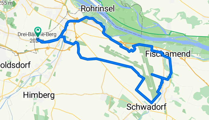
Start Bahnhof Kledering (43km) - Fischteich Mannswörth – Spotterhügel Runde von Kledering
A cycling route starting in Schwechat, Lower Austria, Austria.
Overview
About this route
- 2 h 33 min
- Duration
- 43.7 km
- Distance
- 107 m
- Ascent
- 110 m
- Descent
- 17.1 km/h
- Avg. speed
- 197 m
- Max. altitude

Route quality
Waytypes & surfaces along the route
Waytypes
Track
17 km
(39 %)
Cycleway
13.1 km
(30 %)
Surfaces
Paved
38 km
(87 %)
Unpaved
4.4 km
(10 %)
Asphalt
37.2 km
(85 %)
Gravel
3.5 km
(8 %)
Continue with Bikemap
Use, edit, or download this cycling route
You would like to ride Start Bahnhof Kledering (43km) - Fischteich Mannswörth – Spotterhügel Runde von Kledering or customize it for your own trip? Here is what you can do with this Bikemap route:
Free features
- Save this route as favorite or in collections
- Copy & plan your own version of this route
- Sync your route with Garmin or Wahoo
Premium features
Free trial for 3 days, or one-time payment. More about Bikemap Premium.
- Navigate this route on iOS & Android
- Export a GPX / KML file of this route
- Create your custom printout (try it for free)
- Download this route for offline navigation
Discover more Premium features.
Get Bikemap PremiumFrom our community
Other popular routes starting in Schwechat
 Wien to closest near 0 light pollution place
- Distance
- 69.2 km
- Ascent
- 201 m
- Descent
- 256 m
- Location
- Schwechat, Lower Austria, Austria
 Kaiserebersdorf - Korneuburg - Greifenstein - Klosterneuburg - Kaiserebersdorf
- Distance
- 69.1 km
- Ascent
- 103 m
- Descent
- 102 m
- Location
- Schwechat, Lower Austria, Austria
 Rund um Wien 8.10.2011
- Distance
- 122.7 km
- Ascent
- 701 m
- Descent
- 701 m
- Location
- Schwechat, Lower Austria, Austria
 Radhaus-mttlLobauRunde1
- Distance
- 40.6 km
- Ascent
- 87 m
- Descent
- 90 m
- Location
- Schwechat, Lower Austria, Austria
 Donauinsel / Schloss Hof
- Distance
- 45.5 km
- Ascent
- 764 m
- Descent
- 765 m
- Location
- Schwechat, Lower Austria, Austria
 Start Bahnhof Kledering (43km) - Fischteich Mannswörth – Spotterhügel Runde von Kledering
- Distance
- 43.7 km
- Ascent
- 107 m
- Descent
- 110 m
- Location
- Schwechat, Lower Austria, Austria
 Sellingergasse nach Lánchíd utca
- Distance
- 307.5 km
- Ascent
- 715 m
- Descent
- 751 m
- Location
- Schwechat, Lower Austria, Austria
 HOCHECK (c) RogerB
- Distance
- 66.6 km
- Ascent
- 932 m
- Descent
- 115 m
- Location
- Schwechat, Lower Austria, Austria
Open it in the app