

Overview
About this route
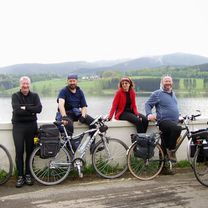
Věra, Matthew, Ivan, Pavlík
- -:--
- Duration
- 63.1 km
- Distance
- 1,137 m
- Ascent
- 1,222 m
- Descent
- ---
- Avg. speed
- 1,234 m
- Max. altitude

Part of
2009_05 Šumava
4 stages
Route quality
Waytypes & surfaces along the route
Waytypes
Track
38.2 km
(61 %)
Road
10 km
(16 %)
Surfaces
Paved
44.8 km
(71 %)
Unpaved
14.1 km
(22 %)
Asphalt
41.4 km
(66 %)
Gravel
5.8 km
(9 %)
Route highlights
Points of interest along the route
Point of interest after 19.3 km
Oběd
Continue with Bikemap
Use, edit, or download this cycling route
You would like to ride Prášily_Volary or customize it for your own trip? Here is what you can do with this Bikemap route:
Free features
- Save this route as favorite or in collections
- Copy & plan your own version of this route
- Sync your route with Garmin or Wahoo
Premium features
Free trial for 3 days, or one-time payment. More about Bikemap Premium.
- Navigate this route on iOS & Android
- Export a GPX / KML file of this route
- Create your custom printout (try it for free)
- Download this route for offline navigation
Discover more Premium features.
Get Bikemap PremiumFrom our community
Other popular routes starting in Hartmanice
 Prášily_Volary
- Distance
- 63.1 km
- Ascent
- 1,137 m
- Descent
- 1,222 m
- Location
- Hartmanice, Plzeň Region, Czechia
 Šumava po hranici
- Distance
- 20 km
- Ascent
- 677 m
- Descent
- 680 m
- Location
- Hartmanice, Plzeň Region, Czechia
 na poledník
- Distance
- 7.8 km
- Ascent
- 465 m
- Descent
- 38 m
- Location
- Hartmanice, Plzeň Region, Czechia
 přes bor
- Distance
- 14 km
- Ascent
- 108 m
- Descent
- 551 m
- Location
- Hartmanice, Plzeň Region, Czechia
 Jiřičná - Keply - Hory Matky Boží - Jiřičná
- Distance
- 36 km
- Ascent
- 562 m
- Descent
- 566 m
- Location
- Hartmanice, Plzeň Region, Czechia
 Sumava: von Prasily runter nach Nova Pec am Lipno-Stausee
- Distance
- 76.9 km
- Ascent
- 936 m
- Descent
- 1,079 m
- Location
- Hartmanice, Plzeň Region, Czechia
 2019_08 Skalka, Poledník, Oblík pěšky
- Distance
- 20.1 km
- Ascent
- 750 m
- Descent
- 641 m
- Location
- Hartmanice, Plzeň Region, Czechia
 Prášily - Gsenget - vodní nádrž Frauenau - Buchenau - Spiegelhütte - Zwieselerwaldhaus - Debrník - Špičácké sedlo - Hamry - Nýrsko - Dubová Lohota - Týnec -Luby
- Distance
- 93.9 km
- Ascent
- 1,065 m
- Descent
- 1,537 m
- Location
- Hartmanice, Plzeň Region, Czechia
Open it in the app