
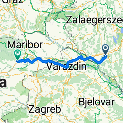
Nagykanizsa - Čitluk
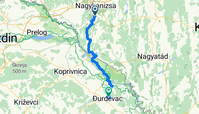
Nagykanizsa - Kalinovac
A cycling route starting in Nagykanizsa, Zala County, Hungary.
Overview
About this route
- 3 h 30 min
- Duration
- 58 km
- Distance
- 171 m
- Ascent
- 217 m
- Descent
- 16.6 km/h
- Avg. speed
- 219 m
- Max. altitude
Part of
Nagykanizsa - Čitluk
15 stages
Route quality
Waytypes & surfaces along the route
Waytypes
Quiet road
25.5 km
(44 %)
Track
11 km
(19 %)
Surfaces
Paved
17.4 km
(30 %)
Unpaved
2.9 km
(5 %)
Asphalt
17.4 km
(30 %)
Gravel
1.7 km
(3 %)
Continue with Bikemap
Use, edit, or download this cycling route
You would like to ride Nagykanizsa - Kalinovac or customize it for your own trip? Here is what you can do with this Bikemap route:
Free features
- Save this route as favorite or in collections
- Copy & plan your own version of this route
- Sync your route with Garmin or Wahoo
Premium features
Free trial for 3 days, or one-time payment. More about Bikemap Premium.
- Navigate this route on iOS & Android
- Export a GPX / KML file of this route
- Create your custom printout (try it for free)
- Download this route for offline navigation
Discover more Premium features.
Get Bikemap PremiumFrom our community
Other popular routes starting in Nagykanizsa
 Várdomb_Homokkomárom_Palin
- Distance
- 18.9 km
- Ascent
- 319 m
- Descent
- 437 m
- Location
- Nagykanizsa, Zala County, Hungary
 Obornak_Várdomb
- Distance
- 3.7 km
- Ascent
- 136 m
- Descent
- 8 m
- Location
- Nagykanizsa, Zala County, Hungary
 Vasút utca, Nagykanizsa - Zgornja Ložnica, Zgornja Ložnica
- Distance
- 153.3 km
- Ascent
- 505 m
- Descent
- 367 m
- Location
- Nagykanizsa, Zala County, Hungary
 MURA_Kanizsa_50
- Distance
- 49.6 km
- Ascent
- 178 m
- Descent
- 178 m
- Location
- Nagykanizsa, Zala County, Hungary
 Murafölde kör 3
- Distance
- 219.8 km
- Ascent
- 2,889 m
- Descent
- 2,891 m
- Location
- Nagykanizsa, Zala County, Hungary
 Nagykanizsa-Milánó 2023
- Distance
- 900.9 km
- Ascent
- 4,743 m
- Descent
- 4,759 m
- Location
- Nagykanizsa, Zala County, Hungary
 Tengerre magyar 1.st day
- Distance
- 174.9 km
- Ascent
- 410 m
- Descent
- 437 m
- Location
- Nagykanizsa, Zala County, Hungary
 Börzönce1
- Distance
- 65.4 km
- Ascent
- 327 m
- Descent
- 327 m
- Location
- Nagykanizsa, Zala County, Hungary
Open it in the app