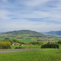
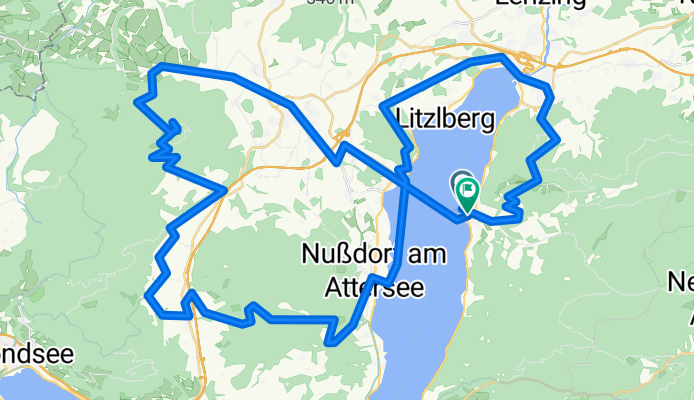
Kabong mit Schiff
A cycling route starting in Attersee, Upper Austria, Austria.
Overview
About this route
- 8 h 10 min
- Duration
- 74.8 km
- Distance
- 1,738 m
- Ascent
- 1,778 m
- Descent
- 9.2 km/h
- Avg. speed
- 866 m
- Max. altitude
Route quality
Waytypes & surfaces along the route
Waytypes
Quiet road
14.2 km
(19 %)
Track
3.7 km
(5 %)
Surfaces
Paved
11.2 km
(15 %)
Unpaved
3.7 km
(5 %)
Asphalt
10.5 km
(14 %)
Gravel
3 km
(4 %)
Continue with Bikemap
Use, edit, or download this cycling route
You would like to ride Kabong mit Schiff or customize it for your own trip? Here is what you can do with this Bikemap route:
Free features
- Save this route as favorite or in collections
- Copy & plan your own version of this route
- Sync your route with Garmin or Wahoo
Premium features
Free trial for 3 days, or one-time payment. More about Bikemap Premium.
- Navigate this route on iOS & Android
- Export a GPX / KML file of this route
- Create your custom printout (try it for free)
- Download this route for offline navigation
Discover more Premium features.
Get Bikemap PremiumFrom our community
Other popular routes starting in Attersee

Garmin
Kabong mit Schiff- Distance
- 74.8 km
- Ascent
- 1,738 m
- Descent
- 1,778 m
- Location
- Attersee, Upper Austria, Austria
Attersee és Mondsee- Distance
- 81.3 km
- Ascent
- 411 m
- Descent
- 411 m
- Location
- Attersee, Upper Austria, Austria
Rund um den Attersee und Buchberg. 🚴♂️🚴- Distance
- 49.8 km
- Ascent
- 921 m
- Descent
- 916 m
- Location
- Attersee, Upper Austria, Austria
Buchberg-Kronberg Runde- Distance
- 21.2 km
- Ascent
- 259 m
- Descent
- 405 m
- Location
- Attersee, Upper Austria, Austria
Itálie 1999 - 2. etapa (30.7.1999)- Distance
- 138.8 km
- Ascent
- 2,393 m
- Descent
- 2,206 m
- Location
- Attersee, Upper Austria, Austria
weyreggrunde- Distance
- 33.5 km
- Ascent
- 697 m
- Descent
- 700 m
- Location
- Attersee, Upper Austria, Austria
Richtberg - Mountainbikestrecke- Distance
- 33.9 km
- Ascent
- 0 m
- Descent
- 0 m
- Location
- Attersee, Upper Austria, Austria
Runde um den Attersee- Distance
- 58.6 km
- Ascent
- 481 m
- Descent
- 467 m
- Location
- Attersee, Upper Austria, Austria
Open it in the app


