
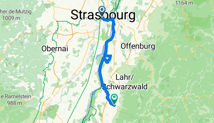
Strasbourg - Strasbourg
1. Strasbourg - Ettenheim
A cycling route starting in Strasbourg, Grand Est, France.
Overview
About this route
- 3 h 47 min
- Duration
- 57.4 km
- Distance
- 189 m
- Ascent
- 164 m
- Descent
- 15.2 km/h
- Avg. speed
- 176 m
- Max. altitude
Part of
Strasbourg - Strasbourg
6 stages
Route quality
Waytypes & surfaces along the route
Waytypes
Track
31.5 km
(55 %)
Quiet road
10.3 km
(18 %)
Surfaces
Paved
25.8 km
(45 %)
Unpaved
25.2 km
(44 %)
Gravel
23.5 km
(41 %)
Asphalt
20.1 km
(35 %)
Continue with Bikemap
Use, edit, or download this cycling route
You would like to ride 1. Strasbourg - Ettenheim or customize it for your own trip? Here is what you can do with this Bikemap route:
Free features
- Save this route as favorite or in collections
- Copy & plan your own version of this route
- Sync your route with Garmin or Wahoo
Premium features
Free trial for 3 days, or one-time payment. More about Bikemap Premium.
- Navigate this route on iOS & Android
- Export a GPX / KML file of this route
- Create your custom printout (try it for free)
- Download this route for offline navigation
Discover more Premium features.
Get Bikemap PremiumFrom our community
Other popular routes starting in Strasbourg
 "Grand" Parcours Route
- Distance
- 56.1 km
- Ascent
- 362 m
- Descent
- 357 m
- Location
- Strasbourg, Grand Est, France
 1. Strasbourg - Ettenheim
- Distance
- 57.4 km
- Ascent
- 189 m
- Descent
- 164 m
- Location
- Strasbourg, Grand Est, France
 Strasbourg Train Station to Marie-Helene
- Distance
- 4.5 km
- Ascent
- 35 m
- Descent
- 44 m
- Location
- Strasbourg, Grand Est, France
 "Moyen" Parcours Route
- Distance
- 40.9 km
- Ascent
- 213 m
- Descent
- 211 m
- Location
- Strasbourg, Grand Est, France
 Strasbourg Drussenheim-Kehl-'Strasbourg
- Distance
- 66.4 km
- Ascent
- 64 m
- Descent
- 66 m
- Location
- Strasbourg, Grand Est, France
 28 juin 2018
- Distance
- 48.3 km
- Ascent
- 64 m
- Descent
- 61 m
- Location
- Strasbourg, Grand Est, France
 Grand tour Bruche et Marne au Rhin
- Distance
- 107.8 km
- Ascent
- 387 m
- Descent
- 388 m
- Location
- Strasbourg, Grand Est, France
 Day 3: Strasbourg to Offenburg
- Distance
- 24.2 km
- Ascent
- 61 m
- Descent
- 40 m
- Location
- Strasbourg, Grand Est, France
Open it in the app