
Bike Across Massachusetts
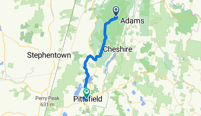
Williamstown - Pittsfield
A cycling route starting in Adams, Massachusetts, United States.
Overview
About this route
- 1 h 55 min
- Duration
- 31.5 km
- Distance
- 251 m
- Ascent
- 998 m
- Descent
- 16.4 km/h
- Avg. speed
- 1,058 m
- Max. altitude

Part of
Bike Across Massachusetts
4 stages
Route quality
Waytypes & surfaces along the route
Waytypes
Quiet road
26.5 km
(84 %)
Road
4.4 km
(14 %)
Access road
0.6 km
(2 %)
Surfaces
Paved
16.1 km
(51 %)
Unpaved
6 km
(19 %)
Asphalt
16.1 km
(51 %)
Unpaved (undefined)
6 km
(19 %)
Undefined
9.5 km
(30 %)
Continue with Bikemap
Use, edit, or download this cycling route
You would like to ride Williamstown - Pittsfield or customize it for your own trip? Here is what you can do with this Bikemap route:
Free features
- Save this route as favorite or in collections
- Copy & plan your own version of this route
- Sync your route with Garmin or Wahoo
Premium features
Free trial for 3 days, or one-time payment. More about Bikemap Premium.
- Navigate this route on iOS & Android
- Export a GPX / KML file of this route
- Create your custom printout (try it for free)
- Download this route for offline navigation
Discover more Premium features.
Get Bikemap PremiumFrom our community
Other popular routes starting in Adams
 Ashuwillticook Trail, Adams to 14 Perry St, North Adams
- Distance
- 73.2 km
- Ascent
- 367 m
- Descent
- 392 m
- Location
- Adams, Massachusetts, United States
 3 Hoosac St, Adams to 3 Hoosac St, Adams
- Distance
- 34.9 km
- Ascent
- 106 m
- Descent
- 110 m
- Location
- Adams, Massachusetts, United States
 3 Hoosac St, Adams to 617–625 Cheshire Rd, Lanesborough
- Distance
- 17.5 km
- Ascent
- 797 m
- Descent
- 816 m
- Location
- Adams, Massachusetts, United States
 Mt. Greylock last 3.6k
- Distance
- 3.6 km
- Ascent
- 153 m
- Descent
- 0 m
- Location
- Adams, Massachusetts, United States
 Steady ride
- Distance
- 30.9 km
- Ascent
- 84 m
- Descent
- 7 m
- Location
- Adams, Massachusetts, United States
 Print Works Drive 25, Adams to Farnams Causeway Road 50, Cheshire
- Distance
- 13.1 km
- Ascent
- 114 m
- Descent
- 23 m
- Location
- Adams, Massachusetts, United States
 Recovered Route
- Distance
- 41.1 km
- Ascent
- 774 m
- Descent
- 773 m
- Location
- Adams, Massachusetts, United States
 19 Park St, Adams to Berkshire Mall Rd, Lanesborough
- Distance
- 17.2 km
- Ascent
- 137 m
- Descent
- 76 m
- Location
- Adams, Massachusetts, United States
Open it in the app