

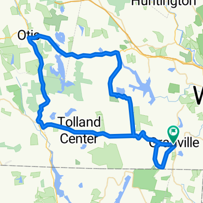
Granville - Otis Loop
A cycling route starting in Granville, Massachusetts, United States.
Overview
About this route
Forty Five mile road loop starting and ending at the triangle in Granville MA. One of my favorite after work rides in this area. Start by heading down 189 S and then take Water St climb for an easier warm up. After the climb on 57 take North Ln and do the upper loop counter-clockwise. Park across from the Granville General Store a good place for water and supplies. Post ride check out Granville Scoop for some great ice cream!
- -:--
- Duration
- 72.3 km
- Distance
- 959 m
- Ascent
- 959 m
- Descent
- ---
- Avg. speed
- ---
- Max. altitude
Route quality
Waytypes & surfaces along the route
Waytypes
Road
18.1 km
(25 %)
Quiet road
3.6 km
(5 %)
Undefined
50.6 km
(70 %)
Surfaces
Paved
26 km
(36 %)
Asphalt
26 km
(36 %)
Undefined
46.3 km
(64 %)
Continue with Bikemap
Use, edit, or download this cycling route
You would like to ride Granville - Otis Loop or customize it for your own trip? Here is what you can do with this Bikemap route:
Free features
- Save this route as favorite or in collections
- Copy & plan your own version of this route
- Sync your route with Garmin or Wahoo
Premium features
Free trial for 3 days, or one-time payment. More about Bikemap Premium.
- Navigate this route on iOS & Android
- Export a GPX / KML file of this route
- Create your custom printout (try it for free)
- Download this route for offline navigation
Discover more Premium features.
Get Bikemap PremiumFrom our community
Other popular routes starting in Granville
 Granville - Otis Loop
- Distance
- 72.3 km
- Ascent
- 959 m
- Descent
- 959 m
- Location
- Granville, Massachusetts, United States
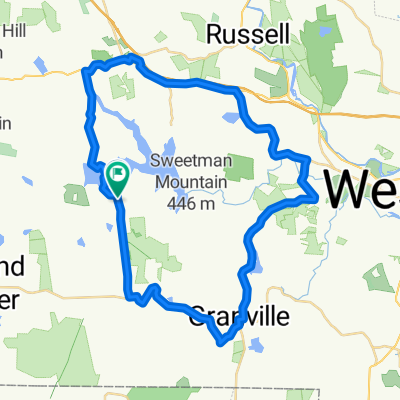 home loop
- Distance
- 46 km
- Ascent
- 706 m
- Descent
- 708 m
- Location
- Granville, Massachusetts, United States
Open it in the app