
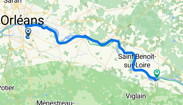
Saint-Jean-le-Blanc à Chemin de la Salle Verte, Sully-sur-Loire
A cycling route starting in Olivet, Centre-Val de Loire, France.
Overview
About this route
- 3 h 42 min
- Duration
- 52.4 km
- Distance
- 71 m
- Ascent
- 52 m
- Descent
- 14.1 km/h
- Avg. speed
- 125 m
- Max. altitude

Route photos


Route quality
Waytypes & surfaces along the route
Waytypes
Quiet road
23.3 km
(44 %)
Cycleway
10.9 km
(21 %)
Surfaces
Paved
27.8 km
(53 %)
Unpaved
10.3 km
(20 %)
Asphalt
24.8 km
(47 %)
Gravel
6.5 km
(12 %)
Continue with Bikemap
Use, edit, or download this cycling route
You would like to ride Saint-Jean-le-Blanc à Chemin de la Salle Verte, Sully-sur-Loire or customize it for your own trip? Here is what you can do with this Bikemap route:
Free features
- Save this route as favorite or in collections
- Copy & plan your own version of this route
- Sync your route with Garmin or Wahoo
Premium features
Free trial for 3 days, or one-time payment. More about Bikemap Premium.
- Navigate this route on iOS & Android
- Export a GPX / KML file of this route
- Create your custom printout (try it for free)
- Download this route for offline navigation
Discover more Premium features.
Get Bikemap PremiumFrom our community
Other popular routes starting in Olivet
 Loire 1.Tag
- Distance
- 44.1 km
- Ascent
- 48 m
- Descent
- 66 m
- Location
- Olivet, Centre-Val de Loire, France
 Olivet-Meung-Olivet
- Distance
- 38.7 km
- Ascent
- 43 m
- Descent
- 42 m
- Location
- Olivet, Centre-Val de Loire, France
 Orleans-Olivet - Montlouis-sur Loire
- Distance
- 109 km
- Ascent
- 71 m
- Descent
- 125 m
- Location
- Olivet, Centre-Val de Loire, France
 Day 39
- Distance
- 144.4 km
- Ascent
- 719 m
- Descent
- 756 m
- Location
- Olivet, Centre-Val de Loire, France
 Petit tour Ardon+ nationale 45min
- Distance
- 24.4 km
- Ascent
- 46 m
- Descent
- 47 m
- Location
- Olivet, Centre-Val de Loire, France
 von orleans nach Blois über Chambord
- Distance
- 87.5 km
- Ascent
- 164 m
- Descent
- 191 m
- Location
- Olivet, Centre-Val de Loire, France
 PB ST2
- Distance
- 119.2 km
- Ascent
- 127 m
- Descent
- 168 m
- Location
- Olivet, Centre-Val de Loire, France
 Ziua 1: Olivet - Briare
- Distance
- 98.4 km
- Ascent
- 157 m
- Descent
- 122 m
- Location
- Olivet, Centre-Val de Loire, France
Open it in the app