
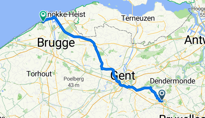
Spaarzaamheidstraat, Aalst naar Koning Leopold III-plein, Blankenberge
A cycling route starting in Aalst, Flemish Region, Belgium.
Overview
About this route
- 5 h 21 min
- Duration
- 94.6 km
- Distance
- 123 m
- Ascent
- 131 m
- Descent
- 17.7 km/h
- Avg. speed
- 32 m
- Max. altitude
Route photos


Route quality
Waytypes & surfaces along the route
Waytypes
Cycleway
54.9 km
(58 %)
Quiet road
28.4 km
(30 %)
Surfaces
Paved
69.1 km
(73 %)
Unpaved
1.9 km
(2 %)
Asphalt
61.5 km
(65 %)
Concrete
7.6 km
(8 %)
Continue with Bikemap
Use, edit, or download this cycling route
You would like to ride Spaarzaamheidstraat, Aalst naar Koning Leopold III-plein, Blankenberge or customize it for your own trip? Here is what you can do with this Bikemap route:
Free features
- Save this route as favorite or in collections
- Copy & plan your own version of this route
- Split it into stages to create a multi-day tour
- Sync your route with Garmin or Wahoo
Premium features
Free trial for 3 days, or one-time payment. More about Bikemap Premium.
- Navigate this route on iOS & Android
- Export a GPX / KML file of this route
- Create your custom printout (try it for free)
- Download this route for offline navigation
Discover more Premium features.
Get Bikemap PremiumFrom our community
Other popular routes starting in Aalst
 mollem-erpe
- Distance
- 17.6 km
- Ascent
- 99 m
- Descent
- 63 m
- Location
- Aalst, Flemish Region, Belgium
 Blaren rijden in
- Distance
- 25.7 km
- Ascent
- 6 m
- Descent
- 21 m
- Location
- Aalst, Flemish Region, Belgium
 From Aalst to Grimbergen
- Distance
- 42.9 km
- Ascent
- 167 m
- Descent
- 157 m
- Location
- Aalst, Flemish Region, Belgium
 Londerzeel loop
- Distance
- 51.9 km
- Ascent
- 92 m
- Descent
- 93 m
- Location
- Aalst, Flemish Region, Belgium
 Sint-Antelinks
- Distance
- 34.7 km
- Ascent
- 192 m
- Descent
- 196 m
- Location
- Aalst, Flemish Region, Belgium
 via scheldeoever of leireken-boom testen
- Distance
- 103.3 km
- Ascent
- 93 m
- Descent
- 96 m
- Location
- Aalst, Flemish Region, Belgium
 Supersnelle route in Aalst
- Distance
- 43.1 km
- Ascent
- 19 m
- Descent
- 33 m
- Location
- Aalst, Flemish Region, Belgium
 Aalst-A'pen
- Distance
- 51.4 km
- Ascent
- 50 m
- Descent
- 50 m
- Location
- Aalst, Flemish Region, Belgium
Open it in the app