
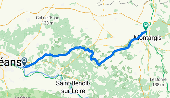
Von Chécy bis Châlette-sur-Loing
A cycling route starting in Chécy, Centre-Val de Loire, France.
Overview
About this route
- 10 h 12 min
- Duration
- 70.2 km
- Distance
- 135 m
- Ascent
- 149 m
- Descent
- 6.9 km/h
- Avg. speed
- 137 m
- Max. altitude

Route quality
Waytypes & surfaces along the route
Waytypes
Cycleway
35.9 km
(51 %)
Path
32.5 km
(46 %)
Surfaces
Paved
36 km
(51 %)
Unpaved
32.6 km
(46 %)
Asphalt
35.9 km
(51 %)
Sand
32.6 km
(46 %)
Route highlights
Points of interest along the route
Bike service after 2.1 km
übergang sicherheit
Drinking water after 6.8 km
Drinking water after 11 km
Toilette, Strom etc. falsche Seite
Point of interest after 21.4 km
Wasserschloss
Drinking water after 21.5 km
Strom, etc.
Accommodation after 23.4 km
Camping
Point of interest after 23.7 km
baden
Point of interest after 25.1 km
Wasserschloss
Bike service after 28.3 km
übergang
Drinking water after 28.3 km
Toilette, Strom etc.
Drinking water after 38.8 km
Drinking water after 43.9 km
Drinking water after 52.7 km
strom toilette liegestühle
Drinking water after 60.3 km
Continue with Bikemap
Use, edit, or download this cycling route
You would like to ride Von Chécy bis Châlette-sur-Loing or customize it for your own trip? Here is what you can do with this Bikemap route:
Free features
- Save this route as favorite or in collections
- Copy & plan your own version of this route
- Sync your route with Garmin or Wahoo
Premium features
Free trial for 3 days, or one-time payment. More about Bikemap Premium.
- Navigate this route on iOS & Android
- Export a GPX / KML file of this route
- Create your custom printout (try it for free)
- Download this route for offline navigation
Discover more Premium features.
Get Bikemap PremiumFrom our community
Other popular routes starting in Chécy
 Chartres-Pouilly sur Loire
- Distance
- 129.2 km
- Ascent
- 156 m
- Descent
- 102 m
- Location
- Chécy, Centre-Val de Loire, France
 Chemin des Pâtures, Chécy naar 4 Place de l'Église, Sury-aux-Bois
- Distance
- 29.4 km
- Ascent
- 337 m
- Descent
- 271 m
- Location
- Chécy, Centre-Val de Loire, France
 De Rue du Bailli Groslot, Saint-Denis-en-Val à Rue des Chevreuils, Saint-Denis-en-Val
- Distance
- 1.1 km
- Ascent
- 0 m
- Descent
- 0 m
- Location
- Chécy, Centre-Val de Loire, France
 Chécy - Gien
- Distance
- 67.9 km
- Ascent
- 183 m
- Descent
- 153 m
- Location
- Chécy, Centre-Val de Loire, France
 E 28: Chemin du Port 35, Chécy nach Le Lac de Loire 5, Vineuil
- Distance
- 71.4 km
- Ascent
- 152 m
- Descent
- 176 m
- Location
- Chécy, Centre-Val de Loire, France
 6:checy-camping municipal bellevue muides sur loiretandem 2017
- Distance
- 56.2 km
- Ascent
- 64 m
- Descent
- 75 m
- Location
- Chécy, Centre-Val de Loire, France
 Von Chécy bis Châlette-sur-Loing
- Distance
- 70.2 km
- Ascent
- 135 m
- Descent
- 149 m
- Location
- Chécy, Centre-Val de Loire, France
 saint etienne sur usson
- Distance
- 371.5 km
- Ascent
- 989 m
- Descent
- 306 m
- Location
- Chécy, Centre-Val de Loire, France
Open it in the app