
KÜHTAI SATTEL (por Kematen)
A cycling route starting in Kematen in Tirol, Tyrol, Austria.
Overview
About this route
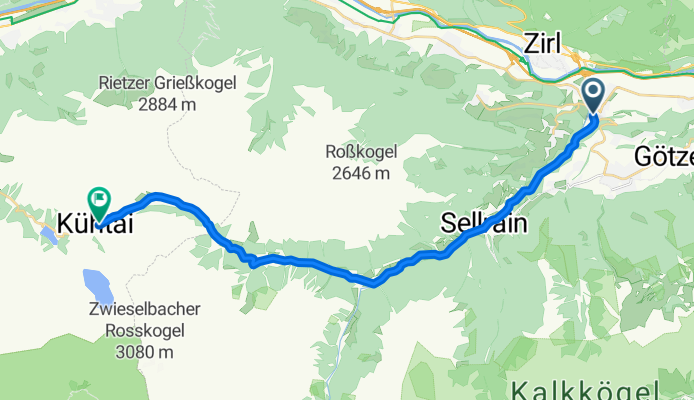
Situated in the heart of the Austrian Tyrol, the Kühtai Sattel (2017 m) is one of those passes that, without making too much noise, ranks among the great alpine passes of Europe. Connecting the Inn valley with the high mountains of Ötztal, its ascent from Kematen in Tirol, very near Innsbruck, represents a long climb, with challenging gradients, spectacular landscapes, and a conclusion at high altitude.
- 1 h 49 min
- Duration
- 23.7 km
- Distance
- 1,562 m
- Ascent
- 158 m
- Descent
- 13 km/h
- Avg. speed
- 2,030 m
- Max. altitude

Route photos
\"")
Route quality
Waytypes & surfaces along the route
Surfaces
Paved
19.4 km
(82 %)
Asphalt
19.4 km
(82 %)
Undefined
4.3 km
(18 %)
Continue with Bikemap
Use, edit, or download this cycling route
You would like to ride KÜHTAI SATTEL (por Kematen) or customize it for your own trip? Here is what you can do with this Bikemap route:
Free features
- Save this route as favorite or in collections
- Copy & plan your own version of this route
- Sync your route with Garmin or Wahoo
Premium features
Free trial for 3 days, or one-time payment. More about Bikemap Premium.
- Navigate this route on iOS & Android
- Export a GPX / KML file of this route
- Create your custom printout (try it for free)
- Download this route for offline navigation
Discover more Premium features.
Get Bikemap PremiumFrom our community
Other popular routes starting in Kematen in Tirol
 1.Ausfahrt 23.3.2019
- Distance
- 16.2 km
- Ascent
- 552 m
- Descent
- 203 m
- Location
- Kematen in Tirol, Tyrol, Austria
 Runde über Völs, 35km/2,5h
- Distance
- 35.7 km
- Ascent
- 1,110 m
- Descent
- 1,103 m
- Location
- Kematen in Tirol, Tyrol, Austria
 Runde über Kühtai
- Distance
- 85.6 km
- Ascent
- 2,380 m
- Descent
- 2,380 m
- Location
- Kematen in Tirol, Tyrol, Austria
 Runde über Innsbruck, 45km, 3h
- Distance
- 45.1 km
- Ascent
- 1,123 m
- Descent
- 1,123 m
- Location
- Kematen in Tirol, Tyrol, Austria
 Kematen - Sölden
- Distance
- 70.1 km
- Ascent
- 1,984 m
- Descent
- 1,269 m
- Location
- Kematen in Tirol, Tyrol, Austria
 Kühtai-Bergtraining
- Distance
- 93 km
- Ascent
- 2,817 m
- Descent
- 2,817 m
- Location
- Kematen in Tirol, Tyrol, Austria
 Pitztalrunde von Kematen aus
- Distance
- 111.3 km
- Ascent
- 900 m
- Descent
- 896 m
- Location
- Kematen in Tirol, Tyrol, Austria
 Rangger Köpfl
- Distance
- 11.8 km
- Ascent
- 1,115 m
- Descent
- 67 m
- Location
- Kematen in Tirol, Tyrol, Austria
Open it in the app