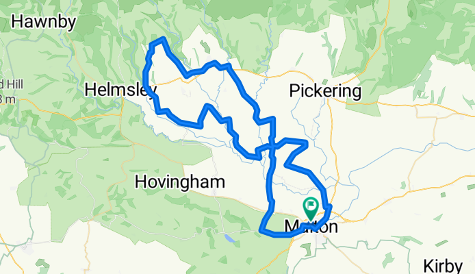
Gravel bike ride
A cycling route starting in Malton, England, United Kingdom.
Overview
About this route
- 3 h 11 min
- Duration
- 72.4 km
- Distance
- 445 m
- Ascent
- 448 m
- Descent
- 22.8 km/h
- Avg. speed
- 191 m
- Max. altitude
Route photos
Route quality
Waytypes & surfaces along the route
Waytypes
Quiet road
41.6 km
(58 %)
Road
25.1 km
(35 %)
Surfaces
Paved
41.6 km
(57 %)
Asphalt
41.1 km
(57 %)
Paved (undefined)
0.5 km
(<1 %)
Undefined
30.8 km
(43 %)
Continue with Bikemap
Use, edit, or download this cycling route
You would like to ride Gravel bike ride or customize it for your own trip? Here is what you can do with this Bikemap route:
Free features
- Save this route as favorite or in collections
- Copy & plan your own version of this route
- Sync your route with Garmin or Wahoo
Premium features
Free trial for 3 days, or one-time payment. More about Bikemap Premium.
- Navigate this route on iOS & Android
- Export a GPX / KML file of this route
- Create your custom printout (try it for free)
- Download this route for offline navigation
Discover more Premium features.
Get Bikemap PremiumFrom our community
Other popular routes starting in Malton
- Norton - Settrington - Scagglethorpe - Norton
- Distance
- 13.6 km
- Ascent
- 75 m
- Descent
- 74 m
- Location
- Malton, England, United Kingdom
- Malton Cattle Market Sledmere Loop 130623 30.9m
- Distance
- 49.7 km
- Ascent
- 610 m
- Descent
- 610 m
- Location
- Malton, England, United Kingdom
- Commercial Street 5A, Norton to Unnamed Road
- Distance
- 10 km
- Ascent
- 164 m
- Descent
- 101 m
- Location
- Malton, England, United Kingdom
- Malton 010920 - 28.2m
- Distance
- 45.6 km
- Ascent
- 429 m
- Descent
- 428 m
- Location
- Malton, England, United Kingdom
- Norton Loop 270320 - 44.8m
- Distance
- 72.3 km
- Ascent
- 412 m
- Descent
- 412 m
- Location
- Malton, England, United Kingdom
- Gravel bike ride
- Distance
- 72.4 km
- Ascent
- 445 m
- Descent
- 448 m
- Location
- Malton, England, United Kingdom
- Braygate St, Swinton, Swinton Grange, Malton to 1 Ryedale Cottages, Main St, Malton
- Distance
- 5.4 km
- Ascent
- 68 m
- Descent
- 108 m
- Location
- Malton, England, United Kingdom
- Rob Stephenson 250519 - 39.1m
- Distance
- 63 km
- Ascent
- 488 m
- Descent
- 486 m
- Location
- Malton, England, United Kingdom
Open it in the app