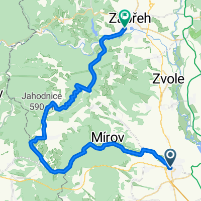
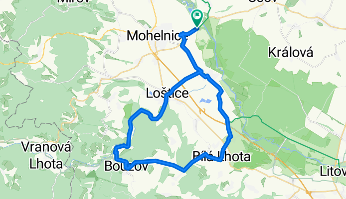
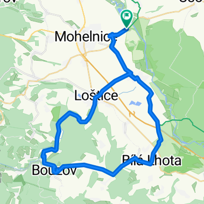
Bouzov - kemp
A cycling route starting in Mohelnice, Olomoucký kraj, Czechia.
Overview
About this route
- 1 h 58 min
- Duration
- 33.5 km
- Distance
- 365 m
- Ascent
- 366 m
- Descent
- 17 km/h
- Avg. speed
- 417 m
- Max. altitude
Route quality
Waytypes & surfaces along the route
Waytypes
Road
18.5 km
(55 %)
Quiet road
5 km
(15 %)
Surfaces
Paved
13.8 km
(41 %)
Unpaved
0.3 km
(1 %)
Asphalt
13.8 km
(41 %)
Loose gravel
0.3 km
(1 %)
Undefined
19.5 km
(58 %)
Continue with Bikemap
Use, edit, or download this cycling route
You would like to ride Bouzov - kemp or customize it for your own trip? Here is what you can do with this Bikemap route:
Free features
- Save this route as favorite or in collections
- Copy & plan your own version of this route
- Sync your route with Garmin or Wahoo
Premium features
Free trial for 3 days, or one-time payment. More about Bikemap Premium.
- Navigate this route on iOS & Android
- Export a GPX / KML file of this route
- Create your custom printout (try it for free)
- Download this route for offline navigation
Discover more Premium features.
Get Bikemap PremiumFrom our community
Other popular routes starting in Mohelnice
Mohelnice-Červená Voda-Jablonné-Č.Petrovice-Žamberk-Česká Třebová- Distance
- 114.6 km
- Ascent
- 1,528 m
- Descent
- 1,459 m
- Location
- Mohelnice, Olomoucký kraj, Czechia
Bouzov - kemp- Distance
- 33.5 km
- Ascent
- 365 m
- Descent
- 366 m
- Location
- Mohelnice, Olomoucký kraj, Czechia
okruh Mohelnice-Maletín-Lázek-Drozd.Pila-Hněvkov-Dolní Bušínov-Mo- Distance
- 76.6 km
- Ascent
- 1,691 m
- Descent
- 1,613 m
- Location
- Mohelnice, Olomoucký kraj, Czechia
Mohelnice Maletín přes Střítež MTB- Distance
- 28.4 km
- Ascent
- 532 m
- Descent
- 338 m
- Location
- Mohelnice, Olomoucký kraj, Czechia
Okolo Mírova 2- Distance
- 43.2 km
- Ascent
- 726 m
- Descent
- 726 m
- Location
- Mohelnice, Olomoucký kraj, Czechia
Mohelnice,Zábřeh,přes Háje aLeštinu po hrázi.- Distance
- 19.7 km
- Ascent
- 60 m
- Descent
- 50 m
- Location
- Mohelnice, Olomoucký kraj, Czechia
3. MP časovka Maletín- Distance
- 10.7 km
- Ascent
- 311 m
- Descent
- 35 m
- Location
- Mohelnice, Olomoucký kraj, Czechia
Okolo Mírova 3- Distance
- 57.5 km
- Ascent
- 767 m
- Descent
- 767 m
- Location
- Mohelnice, Olomoucký kraj, Czechia
Open it in the app


