
우산동 228-18 ~ 우산동 228-18
A cycling route starting in Wŏnju, Gangwon-do, South Korea.
Overview
About this route
- 1 h 11 min
- Duration
- 13.1 km
- Distance
- 69 m
- Ascent
- 110 m
- Descent
- 11 km/h
- Avg. speed
- 148 m
- Max. altitude
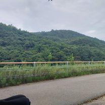
Route photos


Route quality
Waytypes & surfaces along the route
Waytypes
Quiet road
5.5 km
(42 %)
Cycleway
3.7 km
(28 %)
Surfaces
Paved
0.9 km
(7 %)
Asphalt
0.9 km
(7 %)
Undefined
12.2 km
(93 %)
Continue with Bikemap
Use, edit, or download this cycling route
You would like to ride 우산동 228-18 ~ 우산동 228-18 or customize it for your own trip? Here is what you can do with this Bikemap route:
Free features
- Save this route as favorite or in collections
- Copy & plan your own version of this route
- Sync your route with Garmin or Wahoo
Premium features
Free trial for 3 days, or one-time payment. More about Bikemap Premium.
- Navigate this route on iOS & Android
- Export a GPX / KML file of this route
- Create your custom printout (try it for free)
- Download this route for offline navigation
Discover more Premium features.
Get Bikemap PremiumFrom our community
Other popular routes starting in Wŏnju
 명륜동 산35, 원주시 to 명륜동 산35-2, 원주시
- Distance
- 21.5 km
- Ascent
- 104 m
- Descent
- 87 m
- Location
- Wŏnju, Gangwon-do, South Korea
 원주-17양안치-31배재(원주.제천)-45구락재-57치악재-65치악재-94솔티재-97세거리로고개-115피재-123제천
- Distance
- 100.1 km
- Ascent
- 2,040 m
- Descent
- 1,916 m
- Location
- Wŏnju, Gangwon-do, South Korea
![Ph0]에서 경로단구동 156-17, 원주시](https://media.bikemap.net/routes/13458270/staticmaps/in_00378b34-1007-424b-a6fb-5d02e9ac8675_400x400_bikemap-2021-3D-static.png) Ph0]에서 경로단구동 156-17, 원주시
Ph0]에서 경로단구동 156-17, 원주시- Distance
- 21.6 km
- Ascent
- 179 m
- Descent
- 207 m
- Location
- Wŏnju, Gangwon-do, South Korea
 Munmak to Seoul
- Distance
- 121.3 km
- Ascent
- 346 m
- Descent
- 411 m
- Location
- Wŏnju, Gangwon-do, South Korea
![Ph0]에서 경로단구동 114-1](https://www.bikemap.net/media/temp/routes_gallery/c12e6466-c2de-47c6-b9ac-d8e05dae890c.jpg) Ph0]에서 경로단구동 114-1
Ph0]에서 경로단구동 114-1- Distance
- 15 km
- Ascent
- 225 m
- Descent
- 246 m
- Location
- Wŏnju, Gangwon-do, South Korea
 원주-20(횡성)-28전재-39서운재-43(영월)-50(원주)-57(제천)-60오미로고개-75피재-81비끼재(원주)-90구럭재(제천)-104배재(원주)-114서낭고개-132문막
- Distance
- 132.2 km
- Ascent
- 2,881 m
- Descent
- 2,932 m
- Location
- Wŏnju, Gangwon-do, South Korea
 우산동 228-18 ~ 우산동 228-18
- Distance
- 13.1 km
- Ascent
- 69 m
- Descent
- 110 m
- Location
- Wŏnju, Gangwon-do, South Korea
 원주-천은계곡-부론면-남한강-소태재-깊은다리-다릿재-구학산-솔치재-주천 95km 1710m
- Distance
- 95.2 km
- Ascent
- 1,429 m
- Descent
- 1,305 m
- Location
- Wŏnju, Gangwon-do, South Korea
Open it in the app