
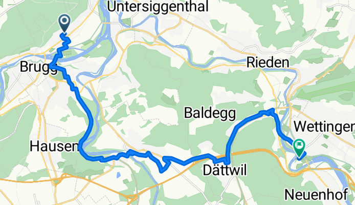
Langmattstrasse nach Klosterstrasse
A cycling route starting in Lauffohr (Brugg), Canton of Aargau, Switzerland.
Overview
About this route
- 1 h
- Duration
- 16.6 km
- Distance
- 261 m
- Ascent
- 235 m
- Descent
- 16.5 km/h
- Avg. speed
- 446 m
- Max. altitude
Route quality
Waytypes & surfaces along the route
Waytypes
Quiet road
7.3 km
(44 %)
Cycleway
6.3 km
(38 %)
Surfaces
Paved
15.3 km
(92 %)
Asphalt
14.8 km
(89 %)
Concrete
0.5 km
(3 %)
Undefined
1.3 km
(8 %)
Continue with Bikemap
Use, edit, or download this cycling route
You would like to ride Langmattstrasse nach Klosterstrasse or customize it for your own trip? Here is what you can do with this Bikemap route:
Free features
- Save this route as favorite or in collections
- Copy & plan your own version of this route
- Sync your route with Garmin or Wahoo
Premium features
Free trial for 3 days, or one-time payment. More about Bikemap Premium.
- Navigate this route on iOS & Android
- Export a GPX / KML file of this route
- Create your custom printout (try it for free)
- Download this route for offline navigation
Discover more Premium features.
Get Bikemap PremiumFrom our community
Other popular routes starting in Lauffohr (Brugg)
 Wiederhergestellte Route
- Distance
- 32.9 km
- Ascent
- 339 m
- Descent
- 339 m
- Location
- Lauffohr (Brugg), Canton of Aargau, Switzerland
 lap flat
- Distance
- 26.7 km
- Ascent
- 113 m
- Descent
- 101 m
- Location
- Lauffohr (Brugg), Canton of Aargau, Switzerland
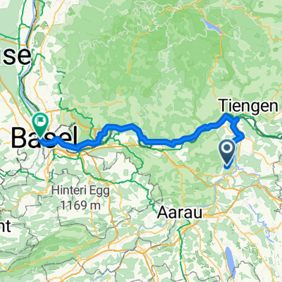 Lauffohr (Brugg) - Basel
- Distance
- 83.2 km
- Ascent
- 500 m
- Descent
- 598 m
- Location
- Lauffohr (Brugg), Canton of Aargau, Switzerland
 Ruine Besserstein- Sennhütte- Linner Wasserfall- Ruine Schenkenberg
- Distance
- 49.1 km
- Ascent
- 1,032 m
- Descent
- 1,026 m
- Location
- Lauffohr (Brugg), Canton of Aargau, Switzerland
 Rund um Brugg
- Distance
- 29.8 km
- Ascent
- 201 m
- Descent
- 201 m
- Location
- Lauffohr (Brugg), Canton of Aargau, Switzerland
 Mellingen-Brugg
- Distance
- 14.5 km
- Ascent
- 93 m
- Descent
- 168 m
- Location
- Lauffohr (Brugg), Canton of Aargau, Switzerland
 Schlussetappe Siggenthal-Menziken
- Distance
- 46.2 km
- Ascent
- 461 m
- Descent
- 226 m
- Location
- Lauffohr (Brugg), Canton of Aargau, Switzerland
 AG Stilli Sulz Klingnau Stilli
- Distance
- 49.8 km
- Ascent
- 852 m
- Descent
- 854 m
- Location
- Lauffohr (Brugg), Canton of Aargau, Switzerland
Open it in the app