
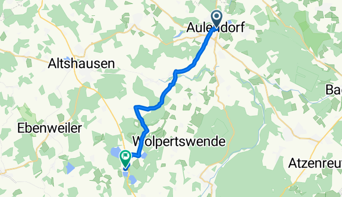
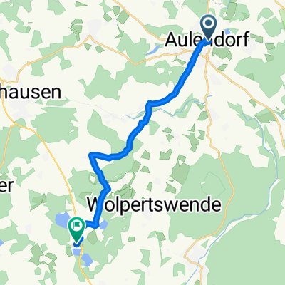
Aulendorf Buchsee
A cycling route starting in Aulendorf, Baden-Wurttemberg, Germany.
Overview
About this route
- 45 min
- Duration
- 12.4 km
- Distance
- 102 m
- Ascent
- 73 m
- Descent
- 16.6 km/h
- Avg. speed
- 601 m
- Max. altitude
Route quality
Waytypes & surfaces along the route
Waytypes
Quiet road
6.9 km
(56 %)
Path
2.5 km
(20 %)
Surfaces
Paved
6.7 km
(54 %)
Unpaved
0.5 km
(4 %)
Asphalt
6.7 km
(54 %)
Loose gravel
0.5 km
(4 %)
Undefined
5.2 km
(42 %)
Continue with Bikemap
Use, edit, or download this cycling route
You would like to ride Aulendorf Buchsee or customize it for your own trip? Here is what you can do with this Bikemap route:
Free features
- Save this route as favorite or in collections
- Copy & plan your own version of this route
- Sync your route with Garmin or Wahoo
Premium features
Free trial for 3 days, or one-time payment. More about Bikemap Premium.
- Navigate this route on iOS & Android
- Export a GPX / KML file of this route
- Create your custom printout (try it for free)
- Download this route for offline navigation
Discover more Premium features.
Get Bikemap PremiumFrom our community
Other popular routes starting in Aulendorf
 Aulendorf - Bodensee - Rheinfall - Tübingen
- Distance
- 268.6 km
- Ascent
- 2,958 m
- Descent
- 3,155 m
- Location
- Aulendorf, Baden-Wurttemberg, Germany
 Unbenannte Route
- Distance
- 68 km
- Ascent
- 1,189 m
- Descent
- 1,350 m
- Location
- Aulendorf, Baden-Wurttemberg, Germany
 Von der Schussen an die Riß
- Distance
- 38.2 km
- Ascent
- 121 m
- Descent
- 121 m
- Location
- Aulendorf, Baden-Wurttemberg, Germany
 Aulendorf n. Bad Waldsee u. Zurück
- Distance
- 25.7 km
- Ascent
- 73 m
- Descent
- 73 m
- Location
- Aulendorf, Baden-Wurttemberg, Germany
 Aulendorf Buchsee
- Distance
- 12.4 km
- Ascent
- 102 m
- Descent
- 73 m
- Location
- Aulendorf, Baden-Wurttemberg, Germany
 Durchs Ried und Moor
- Distance
- 30 km
- Ascent
- 146 m
- Descent
- 157 m
- Location
- Aulendorf, Baden-Wurttemberg, Germany
 Hatzenturm, Vorsee, Altshausen, Baltshaus, Geigelbach
- Distance
- 34.3 km
- Ascent
- 246 m
- Descent
- 247 m
- Location
- Aulendorf, Baden-Wurttemberg, Germany
 Elchenreute Baienfurt Elchenreute
- Distance
- 19.6 km
- Ascent
- 89 m
- Descent
- 191 m
- Location
- Aulendorf, Baden-Wurttemberg, Germany
Open it in the app