
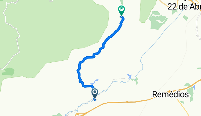
De Estrada do Fa. Parate I a Estrada das Brotas
A cycling route starting in Santa Isabel, São Paulo, Brazil.
Overview
About this route
- 41 min
- Duration
- 8 km
- Distance
- 280 m
- Ascent
- 139 m
- Descent
- 11.8 km/h
- Avg. speed
- 752 m
- Max. altitude
Route photos


Route quality
Waytypes & surfaces along the route
Waytypes
Quiet road
8 km
(100 %)
Surfaces
Paved
0.3 km
(4 %)
Unpaved
7.5 km
(93 %)
Unpaved (undefined)
7.5 km
(93 %)
Asphalt
0.3 km
(4 %)
Undefined
0.2 km
(3 %)
Continue with Bikemap
Use, edit, or download this cycling route
You would like to ride De Estrada do Fa. Parate I a Estrada das Brotas or customize it for your own trip? Here is what you can do with this Bikemap route:
Free features
- Save this route as favorite or in collections
- Copy & plan your own version of this route
- Sync your route with Garmin or Wahoo
Premium features
Free trial for 3 days, or one-time payment. More about Bikemap Premium.
- Navigate this route on iOS & Android
- Export a GPX / KML file of this route
- Create your custom printout (try it for free)
- Download this route for offline navigation
Discover more Premium features.
Get Bikemap PremiumFrom our community
Other popular routes starting in Santa Isabel
 Pouso Alegre
- Distance
- 37.2 km
- Ascent
- 648 m
- Descent
- 648 m
- Location
- Santa Isabel, São Paulo, Brazil
 Igaratá p/ adultos 31,8km Alt810m
- Distance
- 31.8 km
- Ascent
- 709 m
- Descent
- 707 m
- Location
- Santa Isabel, São Paulo, Brazil
 Rota para Estrada Municipal São Bento do Lambari, Mogi das Cruzes
- Distance
- 5.4 km
- Ascent
- 49 m
- Descent
- 22 m
- Location
- Santa Isabel, São Paulo, Brazil
 De Estrada do Fa. Parate I a Estrada das Brotas
- Distance
- 8 km
- Ascent
- 280 m
- Descent
- 139 m
- Location
- Santa Isabel, São Paulo, Brazil
 De Estrada do Fa. Parate I 308 a Estrada do Fa. Parate I 121
- Distance
- 258.2 km
- Ascent
- 12,865 m
- Descent
- 12,836 m
- Location
- Santa Isabel, São Paulo, Brazil
 Ayrton Senna - Campos do Jordão CLONED FROM ROUTE 281553
- Distance
- 145.3 km
- Ascent
- 1,693 m
- Descent
- 749 m
- Location
- Santa Isabel, São Paulo, Brazil
 Rota desde Estrada Municipal São Bento do Lambari, Mogi das Cruzes
- Distance
- 5.9 km
- Ascent
- 43 m
- Descent
- 79 m
- Location
- Santa Isabel, São Paulo, Brazil
 DRE - OUTONO
- Distance
- 136.2 km
- Ascent
- 3,405 m
- Descent
- 3,405 m
- Location
- Santa Isabel, São Paulo, Brazil
Open it in the app