

Konsumring nach Konsumring
A cycling route starting in Ohorn, Saxony, Germany.
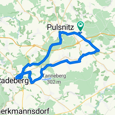
Overview
About this route
- 2 h 16 min
- Duration
- 30.4 km
- Distance
- 284 m
- Ascent
- 333 m
- Descent
- 13.5 km/h
- Avg. speed
- 345 m
- Max. altitude
Route quality
Waytypes & surfaces along the route
Waytypes
Quiet road
11.9 km
(39 %)
Track
7 km
(23 %)
Surfaces
Paved
14 km
(46 %)
Unpaved
7.9 km
(26 %)
Asphalt
13.7 km
(45 %)
Gravel
6.4 km
(21 %)
Continue with Bikemap
Use, edit, or download this cycling route
You would like to ride Konsumring nach Konsumring or customize it for your own trip? Here is what you can do with this Bikemap route:
Free features
- Save this route as favorite or in collections
- Copy & plan your own version of this route
- Sync your route with Garmin or Wahoo
Premium features
Free trial for 3 days, or one-time payment. More about Bikemap Premium.
- Navigate this route on iOS & Android
- Export a GPX / KML file of this route
- Create your custom printout (try it for free)
- Download this route for offline navigation
Discover more Premium features.
Get Bikemap PremiumFrom our community
Other popular routes starting in Ohorn
 MTB_Hochstein
- Distance
- 23.6 km
- Ascent
- 387 m
- Descent
- 390 m
- Location
- Ohorn, Saxony, Germany
 Pulsnitz, Brauna
- Distance
- 71.2 km
- Ascent
- 761 m
- Descent
- 761 m
- Location
- Ohorn, Saxony, Germany
 Ohorn -Radeberg
- Distance
- 35.5 km
- Ascent
- 316 m
- Descent
- 318 m
- Location
- Ohorn, Saxony, Germany
 Ohorn-Dresden
- Distance
- 30.6 km
- Ascent
- 119 m
- Descent
- 327 m
- Location
- Ohorn, Saxony, Germany
 Pulsnitzer Alpen und Seiffersdorfer Tal
- Distance
- 78 km
- Ascent
- 694 m
- Descent
- 786 m
- Location
- Ohorn, Saxony, Germany
 Pulsnitzer Schlösserrunde 2015
- Distance
- 37.5 km
- Ascent
- 322 m
- Descent
- 322 m
- Location
- Ohorn, Saxony, Germany
 Röderradroute 1. Teil bergig
- Distance
- 59.3 km
- Ascent
- 220 m
- Descent
- 338 m
- Location
- Ohorn, Saxony, Germany
 Day 5 V2B
- Distance
- 150.1 km
- Ascent
- 647 m
- Descent
- 921 m
- Location
- Ohorn, Saxony, Germany
Open it in the app