

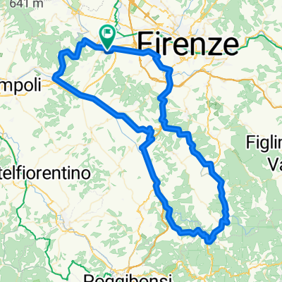
Signa - Pisa
A cycling route starting in Lastra a Signa, Tuscany, Italy.
Overview
About this route
<p>Heavy traffic, the road surface is often crumbling.</p>
Translated, show original (Italian)- -:--
- Duration
- 80.8 km
- Distance
- 77 m
- Ascent
- 112 m
- Descent
- ---
- Avg. speed
- ---
- Max. altitude
Continue with Bikemap
Use, edit, or download this cycling route
You would like to ride Signa - Pisa or customize it for your own trip? Here is what you can do with this Bikemap route:
Free features
- Save this route as favorite or in collections
- Copy & plan your own version of this route
- Split it into stages to create a multi-day tour
- Sync your route with Garmin or Wahoo
Premium features
Free trial for 3 days, or one-time payment. More about Bikemap Premium.
- Navigate this route on iOS & Android
- Export a GPX / KML file of this route
- Create your custom printout (try it for free)
- Download this route for offline navigation
Discover more Premium features.
Get Bikemap PremiumFrom our community
Other popular routes starting in Lastra a Signa
 Renai - Compiobbi
- Distance
- 54.3 km
- Ascent
- 89 m
- Descent
- 92 m
- Location
- Lastra a Signa, Tuscany, Italy
 Da ?4$æ? a ?4$æ?
- Distance
- 30.8 km
- Ascent
- 3 m
- Descent
- 20 m
- Location
- Lastra a Signa, Tuscany, Italy
 Vedute
- Distance
- 103.9 km
- Ascent
- 217 m
- Descent
- 217 m
- Location
- Lastra a Signa, Tuscany, Italy
 ANello Rinascimentale
- Distance
- 126.7 km
- Ascent
- 2,556 m
- Descent
- 2,556 m
- Location
- Lastra a Signa, Tuscany, Italy
 Firenze to Bologna (EV7)
- Distance
- 108 km
- Ascent
- 2,005 m
- Descent
- 1,941 m
- Location
- Lastra a Signa, Tuscany, Italy
 Lastra a Signa-Pontassieve_1^ parte anello del Rinascimento
- Distance
- 94.3 km
- Ascent
- 1,404 m
- Descent
- 1,389 m
- Location
- Lastra a Signa, Tuscany, Italy
 Potential euro trip
- Distance
- 1,391.6 km
- Ascent
- 3,852 m
- Descent
- 3,939 m
- Location
- Lastra a Signa, Tuscany, Italy
 Giro di Panzano & Piazza
- Distance
- 110 km
- Ascent
- 823 m
- Descent
- 821 m
- Location
- Lastra a Signa, Tuscany, Italy
Open it in the app