
Pfarrkirchen im Mühlkreis - Ennsdorf
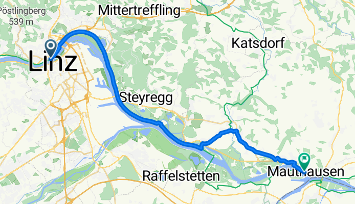
Linz - Ennsdorf
A cycling route starting in Linz, Upper Austria, Austria.
Overview
About this route
- 1 h 15 min
- Duration
- 24.6 km
- Distance
- 50 m
- Ascent
- 64 m
- Descent
- 19.6 km/h
- Avg. speed
- 265 m
- Max. altitude

Part of
Route quality
Waytypes & surfaces along the route
Waytypes
Cycleway
17.5 km
(71 %)
Road
4.2 km
(17 %)
Surfaces
Paved
24.6 km
(100 %)
Asphalt
24.6 km
(100 %)
Continue with Bikemap
Use, edit, or download this cycling route
You would like to ride Linz - Ennsdorf or customize it for your own trip? Here is what you can do with this Bikemap route:
Free features
- Save this route as favorite or in collections
- Copy & plan your own version of this route
- Sync your route with Garmin or Wahoo
Premium features
Free trial for 3 days, or one-time payment. More about Bikemap Premium.
- Navigate this route on iOS & Android
- Export a GPX / KML file of this route
- Create your custom printout (try it for free)
- Download this route for offline navigation
Discover more Premium features.
Get Bikemap PremiumFrom our community
Other popular routes starting in Linz
 Ottensheim
- Distance
- 31.8 km
- Ascent
- 122 m
- Descent
- 124 m
- Location
- Linz, Upper Austria, Austria
 Seeweg nach Seeweg 9, Plesching
- Distance
- 51.1 km
- Ascent
- 155 m
- Descent
- 200 m
- Location
- Linz, Upper Austria, Austria
 Route nach Luftenberg an der Donau
- Distance
- 36.3 km
- Ascent
- 649 m
- Descent
- 658 m
- Location
- Linz, Upper Austria, Austria
 Trail Uni – Windpassing 2
- Distance
- 8.8 km
- Ascent
- 360 m
- Descent
- 360 m
- Location
- Linz, Upper Austria, Austria
 Urfahr-Altenberg-Oberbairing
- Distance
- 28.1 km
- Ascent
- 607 m
- Descent
- 565 m
- Location
- Linz, Upper Austria, Austria
 L-Pelmbergstüberl 03.10.25-L
- Distance
- 25.3 km
- Ascent
- 618 m
- Descent
- 618 m
- Location
- Linz, Upper Austria, Austria
 Leonfeldner Straße 68a nach Leonfeldner Straße 66a
- Distance
- 20.2 km
- Ascent
- 729 m
- Descent
- 774 m
- Location
- Linz, Upper Austria, Austria
 Urfahr/GIS/Urfahr
- Distance
- 23 km
- Ascent
- 653 m
- Descent
- 653 m
- Location
- Linz, Upper Austria, Austria
Open it in the app