

Пішки Тур'ї Ремети - Ярок, розмітка КГ 2012
A cycling route starting in Perechyn, Zakarpattia Oblast, Ukraine.
Overview
About this route
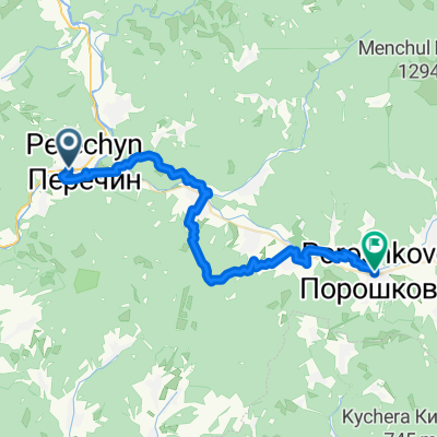
Route of the organizers' walking tour along part of the King of the Mountains 2012 course on the section from the village of Tur'ї Remeti to the village of Yarok. Near Yarok, the pedestrian route diverges somewhat from the King of the Mountains course, so you should follow the markings, not the GPS, meaning on asphalt and not through the forest.
- -:--
- Duration
- 24.7 km
- Distance
- 700 m
- Ascent
- 561 m
- Descent
- ---
- Avg. speed
- ---
- Max. altitude
Continue with Bikemap
Use, edit, or download this cycling route
You would like to ride Пішки Тур'ї Ремети - Ярок, розмітка КГ 2012 or customize it for your own trip? Here is what you can do with this Bikemap route:
Free features
- Save this route as favorite or in collections
- Copy & plan your own version of this route
- Sync your route with Garmin or Wahoo
Premium features
Free trial for 3 days, or one-time payment. More about Bikemap Premium.
- Navigate this route on iOS & Android
- Export a GPX / KML file of this route
- Create your custom printout (try it for free)
- Download this route for offline navigation
Discover more Premium features.
Get Bikemap PremiumFrom our community
Other popular routes starting in Perechyn
 From Perechynska miska hromada to Turi Remety
- Distance
- 38 km
- Ascent
- 935 m
- Descent
- 852 m
- Location
- Perechyn, Zakarpattia Oblast, Ukraine
 Полонина Руна
- Distance
- 83.8 km
- Ascent
- 1,443 m
- Descent
- 1,396 m
- Location
- Perechyn, Zakarpattia Oblast, Ukraine
 От вулиця Шевченка 13, Дубриничі до Вулиця без назви, Чорноголова
- Distance
- 13.3 km
- Ascent
- 395 m
- Descent
- 296 m
- Location
- Perechyn, Zakarpattia Oblast, Ukraine
 Ukraine-2010
- Distance
- 1,359.7 km
- Ascent
- 1,650 m
- Descent
- 1,761 m
- Location
- Perechyn, Zakarpattia Oblast, Ukraine
 Зарічево-гори біля Вільшинків-Ужгород
- Distance
- 55.2 km
- Ascent
- 632 m
- Descent
- 674 m
- Location
- Perechyn, Zakarpattia Oblast, Ukraine
 Ukraina-04
- Distance
- 28.5 km
- Ascent
- 1,345 m
- Descent
- 76 m
- Location
- Perechyn, Zakarpattia Oblast, Ukraine
 Пішки Тур'ї Ремети - Ярок, розмітка КГ 2012
- Distance
- 24.7 km
- Ascent
- 700 m
- Descent
- 561 m
- Location
- Perechyn, Zakarpattia Oblast, Ukraine
 От Заречево, Зарічово до вулиця Минайська 15а, Ужгород
- Distance
- 59.3 km
- Ascent
- 1,044 m
- Descent
- 1,093 m
- Location
- Perechyn, Zakarpattia Oblast, Ukraine
Open it in the app