
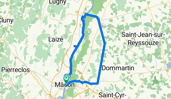
Mâcon - Fleurville - Pont-de-Vaux - Bâge-le-Châtel - Mâcon
A cycling route starting in Saint-Laurent-sur-Saône, Auvergne-Rhône-Alpes, France.
Overview
About this route
- 2 h 47 min
- Duration
- 45.7 km
- Distance
- 125 m
- Ascent
- 132 m
- Descent
- 16.4 km/h
- Avg. speed
- 210 m
- Max. altitude

Route quality
Waytypes & surfaces along the route
Waytypes
Path
15.1 km
(33 %)
Quiet road
3.2 km
(7 %)
Surfaces
Paved
5.5 km
(12 %)
Unpaved
11.9 km
(26 %)
Loose gravel
10.1 km
(22 %)
Asphalt
5.5 km
(12 %)
Continue with Bikemap
Use, edit, or download this cycling route
You would like to ride Mâcon - Fleurville - Pont-de-Vaux - Bâge-le-Châtel - Mâcon or customize it for your own trip? Here is what you can do with this Bikemap route:
Free features
- Save this route as favorite or in collections
- Copy & plan your own version of this route
- Sync your route with Garmin or Wahoo
Premium features
Free trial for 3 days, or one-time payment. More about Bikemap Premium.
- Navigate this route on iOS & Android
- Export a GPX / KML file of this route
- Create your custom printout (try it for free)
- Download this route for offline navigation
Discover more Premium features.
Get Bikemap PremiumFrom our community
Other popular routes starting in Saint-Laurent-sur-Saône
 J4 A/B RC2 MIPIM 2018
- Distance
- 121.7 km
- Ascent
- 340 m
- Descent
- 366 m
- Location
- Saint-Laurent-sur-Saône, Auvergne-Rhône-Alpes, France
 MACON - TOURS 2
- Distance
- 404.2 km
- Ascent
- 2,270 m
- Descent
- 2,396 m
- Location
- Saint-Laurent-sur-Saône, Auvergne-Rhône-Alpes, France
 Mâcon - Fleurville - Pont-de-Vaux - Bâge-le-Châtel - Mâcon
- Distance
- 45.7 km
- Ascent
- 125 m
- Descent
- 132 m
- Location
- Saint-Laurent-sur-Saône, Auvergne-Rhône-Alpes, France
 Mâcon-Pont de veaux
- Distance
- 44 km
- Ascent
- 109 m
- Descent
- 109 m
- Location
- Saint-Laurent-sur-Saône, Auvergne-Rhône-Alpes, France
 28 Rue Jean Jaurès, Saint-Laurent-sur-Saône naar Malay
- Distance
- 93 km
- Ascent
- 4,282 m
- Descent
- 4,255 m
- Location
- Saint-Laurent-sur-Saône, Auvergne-Rhône-Alpes, France
 maconnais 80 km
- Distance
- 77.5 km
- Ascent
- 1,081 m
- Descent
- 1,058 m
- Location
- Saint-Laurent-sur-Saône, Auvergne-Rhône-Alpes, France
 2 Macon - Lyon
- Distance
- 84.6 km
- Ascent
- 263 m
- Descent
- 271 m
- Location
- Saint-Laurent-sur-Saône, Auvergne-Rhône-Alpes, France
 D68A, Replonges to Quai Bouchacourt, Saint-Laurent-sur-Saône
- Distance
- 0.4 km
- Ascent
- 0 m
- Descent
- 64 m
- Location
- Saint-Laurent-sur-Saône, Auvergne-Rhône-Alpes, France
Open it in the app