
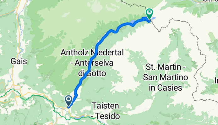
PASSO STALLER/ STALLER SATTER (por Niederrasen/Rasun di Sotto)
A cycling route starting in Rasun Anterselva - Rasen-Antholz, Trentino-Alto Adige, Italy.
Overview
About this route
The Passo Staller, or Staller Sattel in German, is a high mountain pass connecting the Anterselva valley in Italy with the Defreggen valley in Austria. Its Italian side is characterized by a very gentle start in an environment of meadows and small alpine settlements, then transforming into a much more demanding climb in the final part, as the road enters the forest and faces double-digit gradients. The ascent combines long sections of easy pedaling with hard, consecutive ramps. Its summit, at 2052 meters, offers spectacular views of Lake Obersee and the mountains of the Vedrette di Ries-Aurina Nature Park.
- 1 h 34 min
- Duration
- 23.3 km
- Distance
- 1,281 m
- Ascent
- 242 m
- Descent
- 14.9 km/h
- Avg. speed
- 2,046 m
- Max. altitude

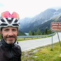
Route photos
\"")
Route quality
Waytypes & surfaces along the route
Waytypes
Road
6.5 km
(28 %)
Quiet road
0.2 km
(1 %)
Undefined
16.6 km
(71 %)
Surfaces
Paved
22.2 km
(95 %)
Asphalt
22.2 km
(95 %)
Undefined
1.2 km
(5 %)
Continue with Bikemap
Use, edit, or download this cycling route
You would like to ride PASSO STALLER/ STALLER SATTER (por Niederrasen/Rasun di Sotto) or customize it for your own trip? Here is what you can do with this Bikemap route:
Free features
- Save this route as favorite or in collections
- Copy & plan your own version of this route
- Sync your route with Garmin or Wahoo
Premium features
Free trial for 3 days, or one-time payment. More about Bikemap Premium.
- Navigate this route on iOS & Android
- Export a GPX / KML file of this route
- Create your custom printout (try it for free)
- Download this route for offline navigation
Discover more Premium features.
Get Bikemap PremiumFrom our community
Other popular routes starting in Rasun Anterselva - Rasen-Antholz
 anterselva
- Distance
- 6.5 km
- Ascent
- 180 m
- Descent
- 44 m
- Location
- Rasun Anterselva - Rasen-Antholz, Trentino-Alto Adige, Italy
 e bike enduro
- Distance
- 29.8 km
- Ascent
- 1,782 m
- Descent
- 1,782 m
- Location
- Rasun Anterselva - Rasen-Antholz, Trentino-Alto Adige, Italy
 Val Pusteria 8) Rasun di Sopra- Braies
- Distance
- 40.3 km
- Ascent
- 808 m
- Descent
- 811 m
- Location
- Rasun Anterselva - Rasen-Antholz, Trentino-Alto Adige, Italy
 3 Brunico - Grossglockner
- Distance
- 121.8 km
- Ascent
- 2,126 m
- Descent
- 859 m
- Location
- Rasun Anterselva - Rasen-Antholz, Trentino-Alto Adige, Italy
 Staller Sattel
- Distance
- 115.2 km
- Ascent
- 2,225 m
- Descent
- 2,225 m
- Location
- Rasun Anterselva - Rasen-Antholz, Trentino-Alto Adige, Italy
 PASSO STALLER/ STALLER SATTER (por Niederrasen/Rasun di Sotto)
- Distance
- 23.3 km
- Ascent
- 1,281 m
- Descent
- 242 m
- Location
- Rasun Anterselva - Rasen-Antholz, Trentino-Alto Adige, Italy
 Val Pusteria 9) Giretto sciallo a Anterselva
- Distance
- 16.3 km
- Ascent
- 205 m
- Descent
- 202 m
- Location
- Rasun Anterselva - Rasen-Antholz, Trentino-Alto Adige, Italy
 e bike tour kreuzjoch senses platz
- Distance
- 113.5 km
- Ascent
- 2,984 m
- Descent
- 3,003 m
- Location
- Rasun Anterselva - Rasen-Antholz, Trentino-Alto Adige, Italy
Open it in the app