

2. wienerwaldfahrt 2009
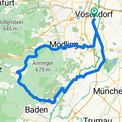
A cycling route starting in Vösendorf, Lower Austria, Austria.
Overview
About this route
start this morning at otto probst street, then head out along the liesing - perchtoldsdorf - brunn - hinterbrühl - gaaden - heiligenkreuz - grub - lunch at gasthaus schöny - wolfsgraben - tullnerbach - sieghartskirchen - königsstetten - muckendorf/wipfing - back along the danube to vienna, then danube canal - line 2 - gumpendorfer - vienna 5
- -:--
- Duration
- 113.4 km
- Distance
- 964 m
- Ascent
- 989 m
- Descent
- ---
- Avg. speed
- 526 m
- Max. altitude

Route quality
Waytypes & surfaces along the route
Waytypes
Cycleway
32.9 km
(29 %)
Quiet road
14.7 km
(13 %)
Surfaces
Paved
90.7 km
(80 %)
Unpaved
3.4 km
(3 %)
Asphalt
89.6 km
(79 %)
Gravel
2.3 km
(2 %)
Route highlights
Points of interest along the route
Point of interest after 38 km
Gasthaus Schöny
Continue with Bikemap
Use, edit, or download this cycling route
You would like to ride 2. wienerwaldfahrt 2009 or customize it for your own trip? Here is what you can do with this Bikemap route:
Free features
- Save this route as favorite or in collections
- Copy & plan your own version of this route
- Split it into stages to create a multi-day tour
- Sync your route with Garmin or Wahoo
Premium features
Free trial for 3 days, or one-time payment. More about Bikemap Premium.
- Navigate this route on iOS & Android
- Export a GPX / KML file of this route
- Create your custom printout (try it for free)
- Download this route for offline navigation
Discover more Premium features.
Get Bikemap PremiumFrom our community
Other popular routes starting in Vösendorf
 Perchtolsdorfer Heide - Anninger
- Distance
- 44.6 km
- Ascent
- 808 m
- Descent
- 818 m
- Location
- Vösendorf, Lower Austria, Austria
 Laxenburg
- Distance
- 14.2 km
- Ascent
- 13 m
- Descent
- 6 m
- Location
- Vösendorf, Lower Austria, Austria
 St.Corona am Schöpfel und retour
- Distance
- 105.5 km
- Ascent
- 859 m
- Descent
- 859 m
- Location
- Vösendorf, Lower Austria, Austria
 Laxenburg
- Distance
- 15.6 km
- Ascent
- 37 m
- Descent
- 61 m
- Location
- Vösendorf, Lower Austria, Austria
 St.Corona am Schöpfel und retour
- Distance
- 108.1 km
- Ascent
- 1,208 m
- Descent
- 1,206 m
- Location
- Vösendorf, Lower Austria, Austria
 Roter Ofen Umweg
- Distance
- 46.2 km
- Ascent
- 403 m
- Descent
- 402 m
- Location
- Vösendorf, Lower Austria, Austria
 Schöpfwerk - Wiener Hütte
- Distance
- 25.4 km
- Ascent
- 227 m
- Descent
- 227 m
- Location
- Vösendorf, Lower Austria, Austria
 Um den Anninger
- Distance
- 42.5 km
- Ascent
- 347 m
- Descent
- 351 m
- Location
- Vösendorf, Lower Austria, Austria
Open it in the app