
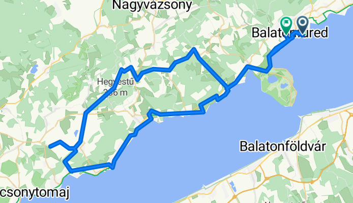
Aranyhíd sétány, Balatonfüred - Castricum tér, Balatonfüred
A cycling route starting in Csopak, Veszprém megye, Hungary.
Overview
About this route
- 5 h 9 min
- Duration
- 84.6 km
- Distance
- 732 m
- Ascent
- 710 m
- Descent
- 16.4 km/h
- Avg. speed
- 319 m
- Max. altitude
Route quality
Waytypes & surfaces along the route
Waytypes
Quiet road
29.6 km
(35 %)
Cycleway
23.7 km
(28 %)
Surfaces
Paved
67.7 km
(80 %)
Unpaved
7.6 km
(9 %)
Asphalt
66.9 km
(79 %)
Ground
5.1 km
(6 %)
Continue with Bikemap
Use, edit, or download this cycling route
You would like to ride Aranyhíd sétány, Balatonfüred - Castricum tér, Balatonfüred or customize it for your own trip? Here is what you can do with this Bikemap route:
Free features
- Save this route as favorite or in collections
- Copy & plan your own version of this route
- Split it into stages to create a multi-day tour
- Sync your route with Garmin or Wahoo
Premium features
Free trial for 3 days, or one-time payment. More about Bikemap Premium.
- Navigate this route on iOS & Android
- Export a GPX / KML file of this route
- Create your custom printout (try it for free)
- Download this route for offline navigation
Discover more Premium features.
Get Bikemap PremiumFrom our community
Other popular routes starting in Csopak
 Vasút utca, Alsóörs - Camping utca, Paloznak
- Distance
- 55.1 km
- Ascent
- 320 m
- Descent
- 318 m
- Location
- Csopak, Veszprém megye, Hungary
 Balatonbikefest bejárás
- Distance
- 103.7 km
- Ascent
- 719 m
- Descent
- 720 m
- Location
- Csopak, Veszprém megye, Hungary
 Útvonal innen: May János utca
- Distance
- 23.2 km
- Ascent
- 225 m
- Descent
- 209 m
- Location
- Csopak, Veszprém megye, Hungary
 Restful route in Balatonkenese
- Distance
- 26.4 km
- Ascent
- 147 m
- Descent
- 94 m
- Location
- Csopak, Veszprém megye, Hungary
 Balatonfured-Revfulop oda-vissza 33fokban
- Distance
- 56.4 km
- Ascent
- 201 m
- Descent
- 201 m
- Location
- Csopak, Veszprém megye, Hungary
 From Balatonfured to Tihany
- Distance
- 216.5 km
- Ascent
- 827 m
- Descent
- 827 m
- Location
- Csopak, Veszprém megye, Hungary
 May János utca - Széchenyi István utca
- Distance
- 31.6 km
- Ascent
- 187 m
- Descent
- 267 m
- Location
- Csopak, Veszprém megye, Hungary
 Fenyves utca, Felsőörs - Fenyves utca, Felsőörs
- Distance
- 30.8 km
- Ascent
- 255 m
- Descent
- 258 m
- Location
- Csopak, Veszprém megye, Hungary
Open it in the app