
Steady ride
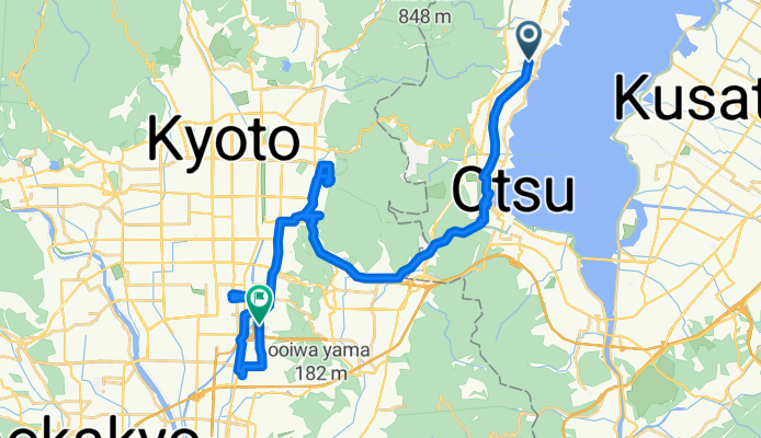
A cycling route starting in Ōtsu, Shiga Prefecture, Japan.
Overview
About this route
- 6 h 5 min
- Duration
- 45.3 km
- Distance
- 561 m
- Ascent
- 649 m
- Descent
- 7.5 km/h
- Avg. speed
- 221 m
- Max. altitude

Route photos


Continue with Bikemap
Use, edit, or download this cycling route
You would like to ride Steady ride or customize it for your own trip? Here is what you can do with this Bikemap route:
Free features
- Save this route as favorite or in collections
- Copy & plan your own version of this route
- Sync your route with Garmin or Wahoo
Premium features
Free trial for 3 days, or one-time payment. More about Bikemap Premium.
- Navigate this route on iOS & Android
- Export a GPX / KML file of this route
- Create your custom printout (try it for free)
- Download this route for offline navigation
Discover more Premium features.
Get Bikemap PremiumFrom our community
Other popular routes starting in Ōtsu
 2, Otsu to 4, Otsu
- Distance
- 165.1 km
- Ascent
- 809 m
- Descent
- 809 m
- Location
- Ōtsu, Shiga Prefecture, Japan
 2016Tour-Otsu
- Distance
- 12.2 km
- Ascent
- 232 m
- Descent
- 303 m
- Location
- Ōtsu, Shiga Prefecture, Japan
 ootsu_nagahama
- Distance
- 76.3 km
- Ascent
- 89 m
- Descent
- 110 m
- Location
- Ōtsu, Shiga Prefecture, Japan
 ビワイチ4(南志賀-瀬田唐橋-草津)
- Distance
- 24.2 km
- Ascent
- 41 m
- Descent
- 113 m
- Location
- Ōtsu, Shiga Prefecture, Japan
 Biwa circuit
- Distance
- 199 km
- Ascent
- 405 m
- Descent
- 404 m
- Location
- Ōtsu, Shiga Prefecture, Japan
 イオンモール草津から小関越え往復
- Distance
- 19.4 km
- Ascent
- 294 m
- Descent
- 293 m
- Location
- Ōtsu, Shiga Prefecture, Japan
 イージーライド
- Distance
- 20.1 km
- Ascent
- 380 m
- Descent
- 382 m
- Location
- Ōtsu, Shiga Prefecture, Japan
 2016Tour-Kyoto
- Distance
- 59.5 km
- Ascent
- 182 m
- Descent
- 160 m
- Location
- Ōtsu, Shiga Prefecture, Japan
Open it in the app