

Am Eichberg, Artstetten-Pöbring nach Donaustraße, Persenbeug-Gottsdorf
A cycling route starting in Klein-Pöchlarn, Lower Austria, Austria.
Overview
About this route
- 37 min
- Duration
- 12.9 km
- Distance
- 101 m
- Ascent
- 279 m
- Descent
- 20.9 km/h
- Avg. speed
- 418 m
- Max. altitude
Route quality
Waytypes & surfaces along the route
Waytypes
Track
6.6 km
(51 %)
Quiet road
2.7 km
(21 %)
Surfaces
Paved
10.2 km
(79 %)
Unpaved
1.3 km
(10 %)
Asphalt
9.7 km
(75 %)
Gravel
1.3 km
(10 %)
Continue with Bikemap
Use, edit, or download this cycling route
You would like to ride Am Eichberg, Artstetten-Pöbring nach Donaustraße, Persenbeug-Gottsdorf or customize it for your own trip? Here is what you can do with this Bikemap route:
Free features
- Save this route as favorite or in collections
- Copy & plan your own version of this route
- Sync your route with Garmin or Wahoo
Premium features
Free trial for 3 days, or one-time payment. More about Bikemap Premium.
- Navigate this route on iOS & Android
- Export a GPX / KML file of this route
- Create your custom printout (try it for free)
- Download this route for offline navigation
Discover more Premium features.
Get Bikemap PremiumFrom our community
Other popular routes starting in Klein-Pöchlarn
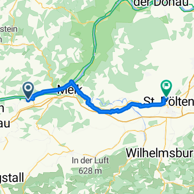 Von Pöchlarn bis Sankt Pölten
- Distance
- 40.6 km
- Ascent
- 206 m
- Descent
- 141 m
- Location
- Klein-Pöchlarn, Lower Austria, Austria
 Taferl Runde
- Distance
- 16.1 km
- Ascent
- 291 m
- Descent
- 292 m
- Location
- Klein-Pöchlarn, Lower Austria, Austria
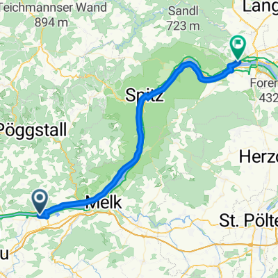 Pochlam - Krems an der Donau
- Distance
- 45 km
- Ascent
- 406 m
- Descent
- 421 m
- Location
- Klein-Pöchlarn, Lower Austria, Austria
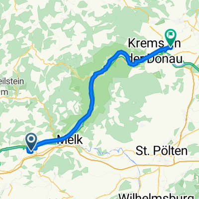
 Donauradweg Runde
- Distance
- 37.1 km
- Ascent
- 86 m
- Descent
- 86 m
- Location
- Klein-Pöchlarn, Lower Austria, Austria
 L5325 54a - Obere Hauptstraße
- Distance
- 54.2 km
- Ascent
- 221 m
- Descent
- 238 m
- Location
- Klein-Pöchlarn, Lower Austria, Austria
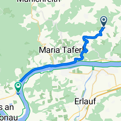 Am Eichberg, Artstetten-Pöbring nach Donaustraße, Persenbeug-Gottsdorf
- Distance
- 12.9 km
- Ascent
- 101 m
- Descent
- 279 m
- Location
- Klein-Pöchlarn, Lower Austria, Austria
 Erlauftalradweg
- Distance
- 164.1 km
- Ascent
- 2,052 m
- Descent
- 2,044 m
- Location
- Klein-Pöchlarn, Lower Austria, Austria
 Von Pöchlarn bis Gaming
- Distance
- 57.8 km
- Ascent
- 905 m
- Descent
- 519 m
- Location
- Klein-Pöchlarn, Lower Austria, Austria
Open it in the app