

Meine große Runde
A cycling route starting in Gropiusstadt, State of Berlin, Germany.
Overview
About this route
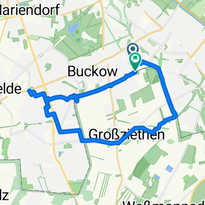
From Großziethen over to Fuchsberg, along a bike path of the 96. Then unfortunately the country road until the intersection towards Großbeeren. Once you pass the monument, it becomes beautiful. Up to Zossen. Then again next to the 96, towards Großmachnow, then towards Klein Kienitz, Brusendorf. Here comes my favorite route. Towards Tollkrug. To the new south runway, up to Selchow, Waßmannsdorf and home.
- -:--
- Duration
- 80.8 km
- Distance
- 115 m
- Ascent
- 115 m
- Descent
- ---
- Avg. speed
- 60 m
- Max. altitude
Route quality
Waytypes & surfaces along the route
Waytypes
Quiet road
21 km
(26 %)
Path
16.2 km
(20 %)
Surfaces
Paved
67.1 km
(83 %)
Unpaved
5.7 km
(7 %)
Asphalt
66.3 km
(82 %)
Gravel
3.2 km
(4 %)
Continue with Bikemap
Use, edit, or download this cycling route
You would like to ride Meine große Runde or customize it for your own trip? Here is what you can do with this Bikemap route:
Free features
- Save this route as favorite or in collections
- Copy & plan your own version of this route
- Split it into stages to create a multi-day tour
- Sync your route with Garmin or Wahoo
Premium features
Free trial for 3 days, or one-time payment. More about Bikemap Premium.
- Navigate this route on iOS & Android
- Export a GPX / KML file of this route
- Create your custom printout (try it for free)
- Download this route for offline navigation
Discover more Premium features.
Get Bikemap PremiumFrom our community
Other popular routes starting in Gropiusstadt
 Landreiterweg nach Schloss Diedersdorf - Großbeeren
- Distance
- 14.5 km
- Ascent
- 36 m
- Descent
- 40 m
- Location
- Gropiusstadt, State of Berlin, Germany
 Landreiterweg, Berlin nach Ringslebenstraße, Berlin
- Distance
- 17.4 km
- Ascent
- 18 m
- Descent
- 18 m
- Location
- Gropiusstadt, State of Berlin, Germany
 Weg zu Uni (FU-Berlin)
- Distance
- 15 km
- Ascent
- 27 m
- Descent
- 22 m
- Location
- Gropiusstadt, State of Berlin, Germany
 Fast Perfekt
- Distance
- 72 km
- Ascent
- 122 m
- Descent
- 125 m
- Location
- Gropiusstadt, State of Berlin, Germany
 Müggelseeroute
- Distance
- 59.8 km
- Ascent
- 93 m
- Descent
- 97 m
- Location
- Gropiusstadt, State of Berlin, Germany
 Landreiterweg nach Nahmitzer Damm dann Schloss Diedersdorf
- Distance
- 17.5 km
- Ascent
- 47 m
- Descent
- 51 m
- Location
- Gropiusstadt, State of Berlin, Germany
 Augenlicht 2015 Zusatzrunde ca 15 km
- Distance
- 19.6 km
- Ascent
- 49 m
- Descent
- 49 m
- Location
- Gropiusstadt, State of Berlin, Germany
 Meine abgewandelte 40 er Strecke
- Distance
- 35.3 km
- Ascent
- 59 m
- Descent
- 56 m
- Location
- Gropiusstadt, State of Berlin, Germany
Open it in the app