
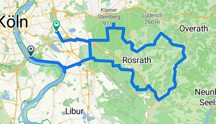
Rundweg mit Stefan
A cycling route starting in Poll, North Rhine-Westphalia, Germany.
Overview
About this route
- 4 h 3 min
- Duration
- 63.8 km
- Distance
- 529 m
- Ascent
- 521 m
- Descent
- 15.7 km/h
- Avg. speed
- 229 m
- Max. altitude
Route quality
Waytypes & surfaces along the route
Waytypes
Path
25.5 km
(40 %)
Quiet road
21.7 km
(34 %)
Surfaces
Paved
44.7 km
(70 %)
Unpaved
12.8 km
(20 %)
Asphalt
41.5 km
(65 %)
Gravel
11.5 km
(18 %)
Continue with Bikemap
Use, edit, or download this cycling route
You would like to ride Rundweg mit Stefan or customize it for your own trip? Here is what you can do with this Bikemap route:
Free features
- Save this route as favorite or in collections
- Copy & plan your own version of this route
- Sync your route with Garmin or Wahoo
Premium features
Free trial for 3 days, or one-time payment. More about Bikemap Premium.
- Navigate this route on iOS & Android
- Export a GPX / KML file of this route
- Create your custom printout (try it for free)
- Download this route for offline navigation
Discover more Premium features.
Get Bikemap PremiumFrom our community
Other popular routes starting in Poll
 Rund um Köln
- Distance
- 43.1 km
- Ascent
- 104 m
- Descent
- 108 m
- Location
- Poll, North Rhine-Westphalia, Germany
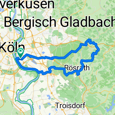
 Drei-Flüsse-Tour Köln
- Distance
- 175.7 km
- Ascent
- 1,295 m
- Descent
- 1,294 m
- Location
- Poll, North Rhine-Westphalia, Germany
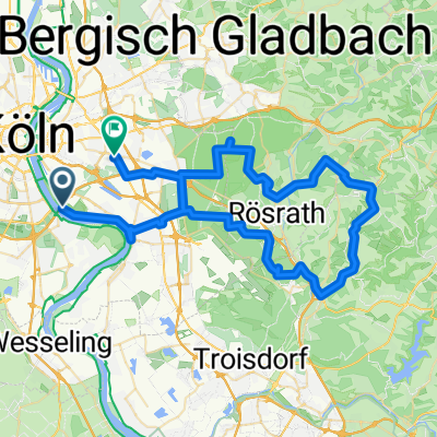
 Poll-Hohkeppel-Altenrath-Poll
- Distance
- 74.5 km
- Ascent
- 289 m
- Descent
- 291 m
- Location
- Poll, North Rhine-Westphalia, Germany
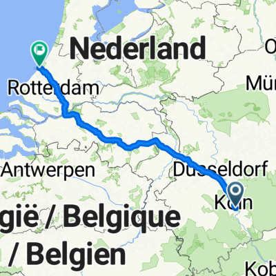 Von Köln bis Den Haag
- Distance
- 297.7 km
- Ascent
- 408 m
- Descent
- 451 m
- Location
- Poll, North Rhine-Westphalia, Germany
 Rundweg mit Stefan
- Distance
- 63.8 km
- Ascent
- 529 m
- Descent
- 521 m
- Location
- Poll, North Rhine-Westphalia, Germany
 Route in Köln
- Distance
- 34.2 km
- Ascent
- 69 m
- Descent
- 68 m
- Location
- Poll, North Rhine-Westphalia, Germany
 Oberländer Ufer 1, Köln nach Vogtstraße 22, Rheinbrohl
- Distance
- 271.8 km
- Ascent
- 1,613 m
- Descent
- 1,598 m
- Location
- Poll, North Rhine-Westphalia, Germany
 65 Gravel Köfo Immek.Heiligenhs.Hoffngthal
- Distance
- 63.6 km
- Ascent
- 1,032 m
- Descent
- 1,031 m
- Location
- Poll, North Rhine-Westphalia, Germany
Open it in the app