

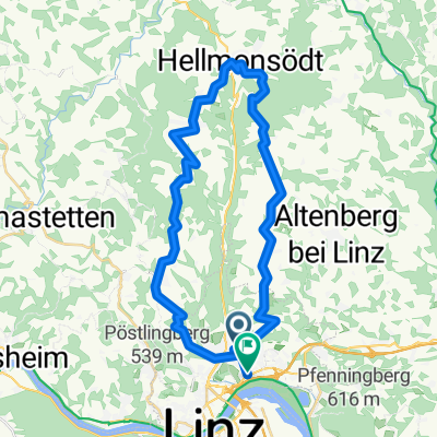
Steyregg Runde
A cycling route starting in Linz, Upper Austria, Austria.
Overview
About this route
Flat until Steyregg, then partially steep
- -:--
- Duration
- 22 km
- Distance
- 218 m
- Ascent
- 220 m
- Descent
- ---
- Avg. speed
- ---
- Max. altitude

Route quality
Waytypes & surfaces along the route
Waytypes
Cycleway
9.3 km
(42 %)
Quiet road
6.4 km
(29 %)
Surfaces
Paved
17.8 km
(81 %)
Unpaved
4 km
(18 %)
Asphalt
17.4 km
(79 %)
Gravel
2.2 km
(10 %)
Continue with Bikemap
Use, edit, or download this cycling route
You would like to ride Steyregg Runde or customize it for your own trip? Here is what you can do with this Bikemap route:
Free features
- Save this route as favorite or in collections
- Copy & plan your own version of this route
- Sync your route with Garmin or Wahoo
Premium features
Free trial for 3 days, or one-time payment. More about Bikemap Premium.
- Navigate this route on iOS & Android
- Export a GPX / KML file of this route
- Create your custom printout (try it for free)
- Download this route for offline navigation
Discover more Premium features.
Get Bikemap PremiumFrom our community
Other popular routes starting in Linz
 L-Pelmbergstüberl 03.10.25-L
- Distance
- 25.3 km
- Ascent
- 618 m
- Descent
- 618 m
- Location
- Linz, Upper Austria, Austria
 Trail GIS – Bachlberg Variante01
- Distance
- 21.7 km
- Ascent
- 713 m
- Descent
- 850 m
- Location
- Linz, Upper Austria, Austria
 Trail Uni – Windpassing 2
- Distance
- 8.8 km
- Ascent
- 360 m
- Descent
- 360 m
- Location
- Linz, Upper Austria, Austria
 Lange Ausfahrt durch Linz
- Distance
- 35.3 km
- Ascent
- 780 m
- Descent
- 794 m
- Location
- Linz, Upper Austria, Austria
 MidlifeCycle 2025 - Day 12 - Ride 1 - Linz to Ybbs
- Distance
- 86.7 km
- Ascent
- 120 m
- Descent
- 161 m
- Location
- Linz, Upper Austria, Austria
 Seeweg nach Seeweg 9, Plesching
- Distance
- 51.1 km
- Ascent
- 155 m
- Descent
- 200 m
- Location
- Linz, Upper Austria, Austria
 Leonfeldner Straße 68a nach Leonfeldner Straße 66a
- Distance
- 20.2 km
- Ascent
- 729 m
- Descent
- 774 m
- Location
- Linz, Upper Austria, Austria
 Trail Pfenningbergrunde
- Distance
- 13.9 km
- Ascent
- 348 m
- Descent
- 350 m
- Location
- Linz, Upper Austria, Austria
Open it in the app