

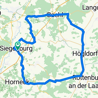
Siegenburg - Oberumelsdorf - Bachl - Kirchdorf
A cycling route starting in Siegenburg, Bavaria, Germany.
Overview
About this route
schöne Trainingsrunde auf ruhigen strassen oder radweg.
- -:--
- Duration
- 50.3 km
- Distance
- 262 m
- Ascent
- 262 m
- Descent
- ---
- Avg. speed
- ---
- Max. altitude
Route quality
Waytypes & surfaces along the route
Waytypes
Busy road
17.8 km
(35 %)
Quiet road
16.4 km
(33 %)
Surfaces
Paved
31.8 km
(63 %)
Unpaved
0.1 km
(<1 %)
Asphalt
31.8 km
(63 %)
Unpaved (undefined)
0.1 km
(<1 %)
Undefined
18.4 km
(37 %)
Continue with Bikemap
Use, edit, or download this cycling route
You would like to ride Siegenburg - Oberumelsdorf - Bachl - Kirchdorf or customize it for your own trip? Here is what you can do with this Bikemap route:
Free features
- Save this route as favorite or in collections
- Copy & plan your own version of this route
- Sync your route with Garmin or Wahoo
Premium features
Free trial for 3 days, or one-time payment. More about Bikemap Premium.
- Navigate this route on iOS & Android
- Export a GPX / KML file of this route
- Create your custom printout (try it for free)
- Download this route for offline navigation
Discover more Premium features.
Get Bikemap PremiumFrom our community
Other popular routes starting in Siegenburg
 Süd-Variante 48
- Distance
- 48.1 km
- Ascent
- 549 m
- Descent
- 553 m
- Location
- Siegenburg, Bavaria, Germany
 MTB Siegenburg
- Distance
- 29.4 km
- Ascent
- 248 m
- Descent
- 250 m
- Location
- Siegenburg, Bavaria, Germany
 Bombenkrater Siegenburg
- Distance
- 14.6 km
- Ascent
- 157 m
- Descent
- 158 m
- Location
- Siegenburg, Bavaria, Germany
 Siegenburg - Illschwang
- Distance
- 116.2 km
- Ascent
- 657 m
- Descent
- 590 m
- Location
- Siegenburg, Bavaria, Germany
 Siegenburg - Oberumelsdorf - Bachl
- Distance
- 51.4 km
- Ascent
- 219 m
- Descent
- 219 m
- Location
- Siegenburg, Bavaria, Germany
 Siegenburg - Oberumelsdorf - Bachl - Kirchdorf
- Distance
- 50.3 km
- Ascent
- 221 m
- Descent
- 221 m
- Location
- Siegenburg, Bavaria, Germany
 Jägerstraße 5, Siegenburg nach Straubinger Straße 46, Abensberg
- Distance
- 8.3 km
- Ascent
- 20 m
- Descent
- 44 m
- Location
- Siegenburg, Bavaria, Germany
 Siegenburg - Oberumelsdorf - Bachl - Kirchdorf
- Distance
- 50.3 km
- Ascent
- 262 m
- Descent
- 262 m
- Location
- Siegenburg, Bavaria, Germany
Open it in the app