
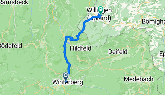
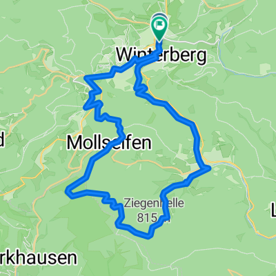
Waltenberg-Tunnel, Winterberg nach Waldecker Straße, Willingen (Upland)
A cycling route starting in Winterberg, North Rhine-Westphalia, Germany.
Overview
About this route
- 1 h 28 min
- Duration
- 19.6 km
- Distance
- 410 m
- Ascent
- 520 m
- Descent
- 13.3 km/h
- Avg. speed
- 795 m
- Max. altitude
Route quality
Waytypes & surfaces along the route
Waytypes
Quiet road
8.2 km
(42 %)
Track
8.2 km
(42 %)
Surfaces
Paved
10.4 km
(53 %)
Unpaved
7.6 km
(39 %)
Asphalt
9.8 km
(50 %)
Gravel
6.9 km
(35 %)
Continue with Bikemap
Use, edit, or download this cycling route
You would like to ride Waltenberg-Tunnel, Winterberg nach Waldecker Straße, Willingen (Upland) or customize it for your own trip? Here is what you can do with this Bikemap route:
Free features
- Save this route as favorite or in collections
- Copy & plan your own version of this route
- Sync your route with Garmin or Wahoo
Premium features
Free trial for 3 days, or one-time payment. More about Bikemap Premium.
- Navigate this route on iOS & Android
- Export a GPX / KML file of this route
- Create your custom printout (try it for free)
- Download this route for offline navigation
Discover more Premium features.
Get Bikemap PremiumFrom our community
Other popular routes starting in Winterberg
 Winterberg - Ottrau
- Distance
- 101.5 km
- Ascent
- 1,074 m
- Descent
- 1,335 m
- Location
- Winterberg, North Rhine-Westphalia, Germany
 Winterberg - Arnsberg
- Distance
- 49.5 km
- Ascent
- 359 m
- Descent
- 729 m
- Location
- Winterberg, North Rhine-Westphalia, Germany
 Ruhrtal-Radweg
- Distance
- 230.4 km
- Ascent
- 125 m
- Descent
- 760 m
- Location
- Winterberg, North Rhine-Westphalia, Germany
 2b Hamm-Uentrop nach Winterberg
- Distance
- 3.5 km
- Ascent
- 102 m
- Descent
- 72 m
- Location
- Winterberg, North Rhine-Westphalia, Germany
 3 Winterberg nach Schwalmstadt
- Distance
- 92 km
- Ascent
- 776 m
- Descent
- 1,331 m
- Location
- Winterberg, North Rhine-Westphalia, Germany
 Küstelberg, Hochheide, Hängebrücke Willingen, Graf Stolberghütte, Titmaringhausen, Küstelberg
- Distance
- 77.1 km
- Ascent
- 1,847 m
- Descent
- 2,022 m
- Location
- Winterberg, North Rhine-Westphalia, Germany
 RuhrtalRadweg - Vreden Tag1
- Distance
- 322.9 km
- Ascent
- 1,244 m
- Descent
- 1,867 m
- Location
- Winterberg, North Rhine-Westphalia, Germany
 Gipfelstürmer Tour 2
- Distance
- 31.4 km
- Ascent
- 852 m
- Descent
- 854 m
- Location
- Winterberg, North Rhine-Westphalia, Germany
Open it in the app