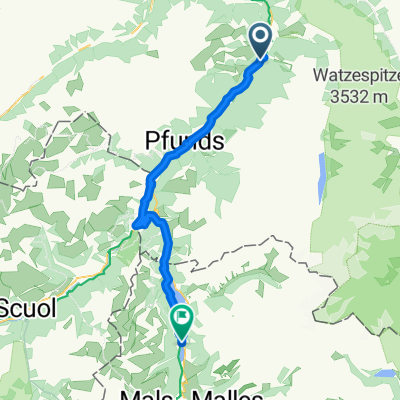
Von München zum Gardasee - Plan
Serfaus - Schlanders
A cycling route starting in Ried im Oberinntal, Tyrol, Austria.
Overview
About this route
- 3 h 21 min
- Duration
- 48.5 km
- Distance
- 1,720 m
- Ascent
- 1,144 m
- Descent
- 14.5 km/h
- Avg. speed
- 1,553 m
- Max. altitude
Part of
Von München zum Gardasee - Plan
6 stages
Route quality
Waytypes & surfaces along the route
Waytypes
Quiet road
15.5 km
(32 %)
Track
9.7 km
(20 %)
Surfaces
Paved
44.1 km
(91 %)
Unpaved
3.9 km
(8 %)
Asphalt
43.6 km
(90 %)
Gravel
2.4 km
(5 %)
Continue with Bikemap
Use, edit, or download this cycling route
You would like to ride Serfaus - Schlanders or customize it for your own trip? Here is what you can do with this Bikemap route:
Free features
- Save this route as favorite or in collections
- Copy & plan your own version of this route
- Sync your route with Garmin or Wahoo
Premium features
Free trial for 3 days, or one-time payment. More about Bikemap Premium.
- Navigate this route on iOS & Android
- Export a GPX / KML file of this route
- Create your custom printout (try it for free)
- Download this route for offline navigation
Discover more Premium features.
Get Bikemap PremiumFrom our community
Other popular routes starting in Ried im Oberinntal
Ried-Pfunds-Martina-Reschenpass-Burgeis-Laas- Distance
- 78.7 km
- Ascent
- 1,165 m
- Descent
- 1,154 m
- Location
- Ried im Oberinntal, Tyrol, Austria
Serfaus - Schlanders- Distance
- 48.5 km
- Ascent
- 1,720 m
- Descent
- 1,144 m
- Location
- Ried im Oberinntal, Tyrol, Austria
Ried im Oberinntal nach Haiming (Innradweg)- Distance
- 51.7 km
- Ascent
- 1,094 m
- Descent
- 1,299 m
- Location
- Ried im Oberinntal, Tyrol, Austria
Kaunertal- Distance
- 47.8 km
- Ascent
- 1,068 m
- Descent
- 1,058 m
- Location
- Ried im Oberinntal, Tyrol, Austria
Ried - Gardasee ( Lazise)- Distance
- 294.9 km
- Ascent
- 849 m
- Descent
- 1,662 m
- Location
- Ried im Oberinntal, Tyrol, Austria
Fl04b Ried - Schlanders- Distance
- 88.7 km
- Ascent
- 1,204 m
- Descent
- 1,348 m
- Location
- Ried im Oberinntal, Tyrol, Austria
Riederhof Rennradtrainingstour 2- Distance
- 16.1 km
- Ascent
- 275 m
- Descent
- 179 m
- Location
- Ried im Oberinntal, Tyrol, Austria
Alpencross Roadbike - Stage 2 - Ried Oberinntal>>Trafoi- Distance
- 80.9 km
- Ascent
- 1,382 m
- Descent
- 739 m
- Location
- Ried im Oberinntal, Tyrol, Austria
Open it in the app


