
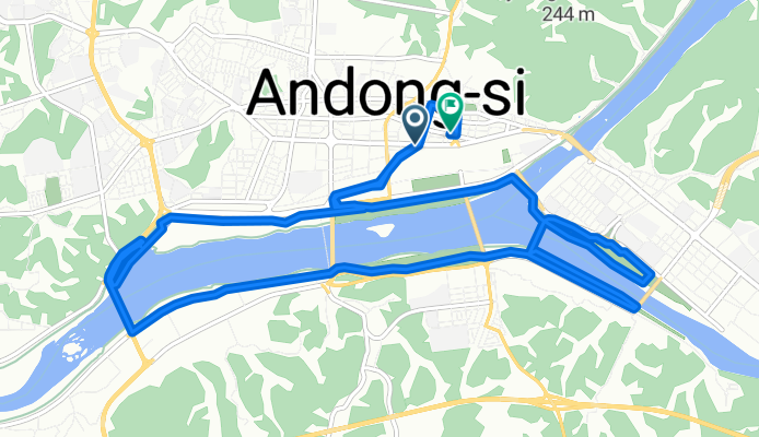
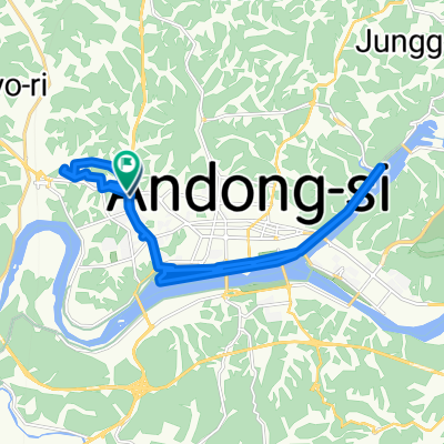
남부동 235-52 ~ 남부동 243-3
A cycling route starting in Andong, Gyeongsangbuk-do, South Korea.
Overview
About this route
- 1 h 20 min
- Duration
- 18 km
- Distance
- 41 m
- Ascent
- 66 m
- Descent
- 13.6 km/h
- Avg. speed
- 123 m
- Max. altitude
Continue with Bikemap
Use, edit, or download this cycling route
You would like to ride 남부동 235-52 ~ 남부동 243-3 or customize it for your own trip? Here is what you can do with this Bikemap route:
Free features
- Save this route as favorite or in collections
- Copy & plan your own version of this route
- Sync your route with Garmin or Wahoo
Premium features
Free trial for 3 days, or one-time payment. More about Bikemap Premium.
- Navigate this route on iOS & Android
- Export a GPX / KML file of this route
- Create your custom printout (try it for free)
- Download this route for offline navigation
Discover more Premium features.
Get Bikemap PremiumFrom our community
Other popular routes starting in Andong
 De Myeongnyun-dong 330-5, Andong à Yeonsan 5(o)-dong
- Distance
- 200.7 km
- Ascent
- 1,933 m
- Descent
- 2,015 m
- Location
- Andong, Gyeongsangbuk-do, South Korea
 상아동 산210, 안동시 to 지보면 93−4, 예천군
- Distance
- 45.3 km
- Ascent
- 1,086 m
- Descent
- 1,120 m
- Location
- Andong, Gyeongsangbuk-do, South Korea
 남부동 235-52 ~ 남부동 243-3
- Distance
- 18 km
- Ascent
- 41 m
- Descent
- 66 m
- Location
- Andong, Gyeongsangbuk-do, South Korea
 수하동 661-18 ~ 수하동 661-18
- Distance
- 30 km
- Ascent
- 142 m
- Descent
- 160 m
- Location
- Andong, Gyeongsangbuk-do, South Korea
 1 parte del Nakdonggang
- Distance
- 144 km
- Ascent
- 762 m
- Descent
- 661 m
- Location
- Andong, Gyeongsangbuk-do, South Korea
![용상동 1193-6, 안동시Ph0]으로 라우팅](https://media.bikemap.net/routes/13395749/staticmaps/in_d916f060-9bdb-4dc4-97f3-d9deae68b46e_400x400_bikemap-2021-3D-static.png) 용상동 1193-6, 안동시Ph0]으로 라우팅
용상동 1193-6, 안동시Ph0]으로 라우팅- Distance
- 65.2 km
- Ascent
- 119 m
- Descent
- 143 m
- Location
- Andong, Gyeongsangbuk-do, South Korea
 2025 1011
- Distance
- 26.2 km
- Ascent
- 252 m
- Descent
- 265 m
- Location
- Andong, Gyeongsangbuk-do, South Korea
 안동-안동호-영주 58km
- Distance
- 58.2 km
- Ascent
- 738 m
- Descent
- 693 m
- Location
- Andong, Gyeongsangbuk-do, South Korea
Open it in the app