

Über die Höhen des Saarlandes 2011 - RTF der Radsportfreunde Körprich e.V. - 151 km Strecke
A cycling route starting in Nalbach, Saarland, Germany.
Overview
About this route
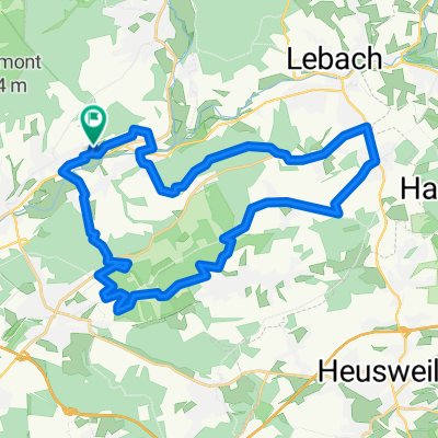
Über die Höhen des Saarlandes 2011 - 151 km
RTF der Radsportfreunde Körprich e.V.
Alle weiteren Hinweise zu dieser Strecke -> hier anklicken
- -:--
- Duration
- 150.9 km
- Distance
- 1,699 m
- Ascent
- 1,587 m
- Descent
- ---
- Avg. speed
- 513 m
- Max. altitude

Route quality
Waytypes & surfaces along the route
Waytypes
Busy road
69.3 km
(46 %)
Road
29.9 km
(20 %)
Surfaces
Paved
122.1 km
(81 %)
Unpaved
6.1 km
(4 %)
Asphalt
118 km
(78 %)
Gravel
2.9 km
(2 %)
Route highlights
Points of interest along the route
Point of interest after 54.6 km
Kontrolle 2 <b>Serrig</b>
Point of interest after 98 km
Kontrolle 1, 3 und 4 <b>Noswendel</b><br> wird 3x angesteuert
Continue with Bikemap
Use, edit, or download this cycling route
You would like to ride Über die Höhen des Saarlandes 2011 - RTF der Radsportfreunde Körprich e.V. - 151 km Strecke or customize it for your own trip? Here is what you can do with this Bikemap route:
Free features
- Save this route as favorite or in collections
- Copy & plan your own version of this route
- Split it into stages to create a multi-day tour
- Sync your route with Garmin or Wahoo
Premium features
Free trial for 3 days, or one-time payment. More about Bikemap Premium.
- Navigate this route on iOS & Android
- Export a GPX / KML file of this route
- Create your custom printout (try it for free)
- Download this route for offline navigation
Discover more Premium features.
Get Bikemap PremiumFrom our community
Other popular routes starting in Nalbach
 Düppenweiler - Hüttersdorf 13.05.2022
- Distance
- 23.7 km
- Ascent
- 530 m
- Descent
- 530 m
- Location
- Nalbach, Saarland, Germany
 27.01.2024
- Distance
- 50 km
- Ascent
- 470 m
- Descent
- 474 m
- Location
- Nalbach, Saarland, Germany
 Schnelle Powerroute
- Distance
- 11.7 km
- Ascent
- 307 m
- Descent
- 307 m
- Location
- Nalbach, Saarland, Germany
 Über die Höhen des Saarlandes 2011 - RTF der Radsportfreunde Körprich e.V. - 151 km Strecke
- Distance
- 150.9 km
- Ascent
- 1,699 m
- Descent
- 1,587 m
- Location
- Nalbach, Saarland, Germany
 Über die Höhen des Saarlandes 2007 - RTF der Radsportfreunde Körprich e.V. - 76 km Strecke
- Distance
- 78.2 km
- Ascent
- 611 m
- Descent
- 612 m
- Location
- Nalbach, Saarland, Germany
 Auf und Ab 2022 - 75 km Permanente der Radsportfreunde Körprich e.V.
- Distance
- 75.4 km
- Ascent
- 868 m
- Descent
- 860 m
- Location
- Nalbach, Saarland, Germany
 Hoxberg und teilweise Schluchtenpfad
- Distance
- 30.1 km
- Ascent
- 405 m
- Descent
- 405 m
- Location
- Nalbach, Saarland, Germany
 40 Km RSF Körprich 2015
- Distance
- 45.1 km
- Ascent
- 208 m
- Descent
- 209 m
- Location
- Nalbach, Saarland, Germany
Open it in the app