
Von Schliersee bis Bruneck
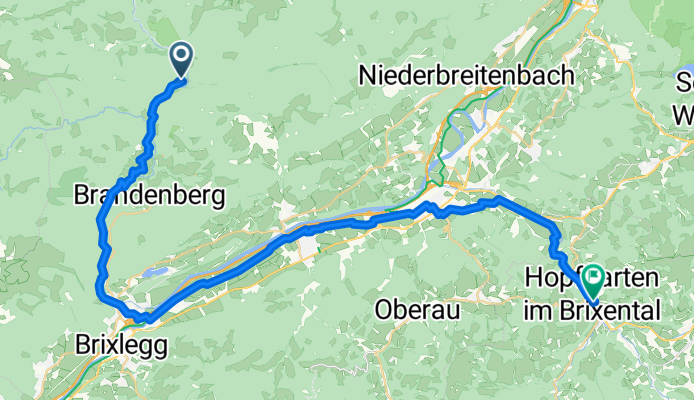
Brandenberg - Hopfgarten (Brixental)
A cycling route starting in Brandenberg, Tyrol, Austria.
Overview
About this route
- 2 h 34 min
- Duration
- 42.6 km
- Distance
- 873 m
- Ascent
- 1,000 m
- Descent
- 16.6 km/h
- Avg. speed
- 857 m
- Max. altitude

Part of
Von Schliersee bis Bruneck
6 stages
Route quality
Waytypes & surfaces along the route
Waytypes
Quiet road
14.9 km
(35 %)
Road
13.2 km
(31 %)
Surfaces
Paved
31.9 km
(75 %)
Unpaved
2.1 km
(5 %)
Asphalt
31.9 km
(75 %)
Gravel
1.3 km
(3 %)
Continue with Bikemap
Use, edit, or download this cycling route
You would like to ride Brandenberg - Hopfgarten (Brixental) or customize it for your own trip? Here is what you can do with this Bikemap route:
Free features
- Save this route as favorite or in collections
- Copy & plan your own version of this route
- Sync your route with Garmin or Wahoo
Premium features
Free trial for 3 days, or one-time payment. More about Bikemap Premium.
- Navigate this route on iOS & Android
- Export a GPX / KML file of this route
- Create your custom printout (try it for free)
- Download this route for offline navigation
Discover more Premium features.
Get Bikemap PremiumFrom our community
Other popular routes starting in Brandenberg
 Steinberg
- Distance
- 26.2 km
- Ascent
- 942 m
- Descent
- 942 m
- Location
- Brandenberg, Tyrol, Austria
 Aschaurunde
- Distance
- 25.4 km
- Ascent
- 675 m
- Descent
- 675 m
- Location
- Brandenberg, Tyrol, Austria
 Tegernsee Hüttentour - Tag3
- Distance
- 27.9 km
- Ascent
- 348 m
- Descent
- 372 m
- Location
- Brandenberg, Tyrol, Austria
 Challenge 117
- Distance
- 117.4 km
- Ascent
- 982 m
- Descent
- 982 m
- Location
- Brandenberg, Tyrol, Austria
 reibaclub tour09 Tag1
- Distance
- 46 km
- Ascent
- 1,124 m
- Descent
- 1,033 m
- Location
- Brandenberg, Tyrol, Austria
 Steinberg2
- Distance
- 27.5 km
- Ascent
- 741 m
- Descent
- 741 m
- Location
- Brandenberg, Tyrol, Austria
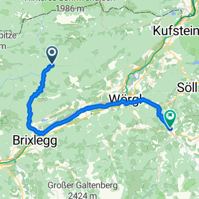 Brandenberg - Hopfgarten (Brixental)
- Distance
- 42.6 km
- Ascent
- 873 m
- Descent
- 1,000 m
- Location
- Brandenberg, Tyrol, Austria
 Rund um die Steinberger Ache
- Distance
- 14.8 km
- Ascent
- 434 m
- Descent
- 432 m
- Location
- Brandenberg, Tyrol, Austria
Open it in the app