
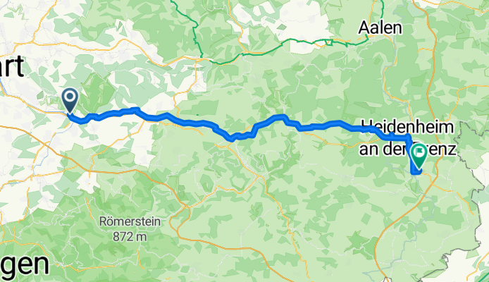
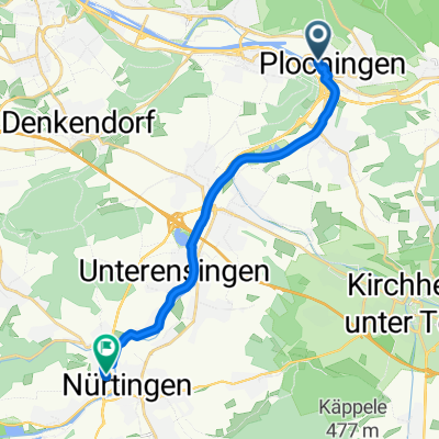
Bahnhof nach Beethovenweg
A cycling route starting in Plochingen, Baden-Wurttemberg, Germany.
Overview
About this route
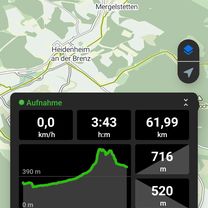
- 4 h 48 min
- Duration
- 75.6 km
- Distance
- 865 m
- Ascent
- 638 m
- Descent
- 15.7 km/h
- Avg. speed
- 715 m
- Max. altitude
Route photos


Route quality
Waytypes & surfaces along the route
Waytypes
Quiet road
31.7 km
(42 %)
Track
17.4 km
(23 %)
Surfaces
Paved
70.3 km
(93 %)
Unpaved
1.5 km
(2 %)
Asphalt
68 km
(90 %)
Paved (undefined)
2.3 km
(3 %)
Continue with Bikemap
Use, edit, or download this cycling route
You would like to ride Bahnhof nach Beethovenweg or customize it for your own trip? Here is what you can do with this Bikemap route:
Free features
- Save this route as favorite or in collections
- Copy & plan your own version of this route
- Sync your route with Garmin or Wahoo
Premium features
Free trial for 3 days, or one-time payment. More about Bikemap Premium.
- Navigate this route on iOS & Android
- Export a GPX / KML file of this route
- Create your custom printout (try it for free)
- Download this route for offline navigation
Discover more Premium features.
Get Bikemap PremiumFrom our community
Other popular routes starting in Plochingen
 Plochingen Faurndau
- Distance
- 38.9 km
- Ascent
- 326 m
- Descent
- 327 m
- Location
- Plochingen, Baden-Wurttemberg, Germany
 Bahnhof nach Beethovenweg
- Distance
- 75.6 km
- Ascent
- 865 m
- Descent
- 638 m
- Location
- Plochingen, Baden-Wurttemberg, Germany
 Große Plochingerrunde
- Distance
- 24.4 km
- Ascent
- 235 m
- Descent
- 235 m
- Location
- Plochingen, Baden-Wurttemberg, Germany
 000_30km_11-Radler_Plochingen-Esslingen
- Distance
- 30.2 km
- Ascent
- 133 m
- Descent
- 150 m
- Location
- Plochingen, Baden-Wurttemberg, Germany
 Bodenseetour 2
- Distance
- 236.9 km
- Ascent
- 2,312 m
- Descent
- 1,973 m
- Location
- Plochingen, Baden-Wurttemberg, Germany
 Plochingen Runde
- Distance
- 15.8 km
- Ascent
- 291 m
- Descent
- 289 m
- Location
- Plochingen, Baden-Wurttemberg, Germany
 Bahnhof nach Stuttgarter Straße
- Distance
- 14 km
- Ascent
- 47 m
- Descent
- 18 m
- Location
- Plochingen, Baden-Wurttemberg, Germany
 20160124_111235.gpx
- Distance
- 21.5 km
- Ascent
- 309 m
- Descent
- 378 m
- Location
- Plochingen, Baden-Wurttemberg, Germany
Open it in the app