
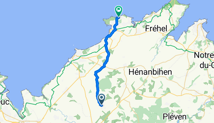
Itinéraire à partir de 3 Rue des Cyprès, Lamballe-Armor
A cycling route starting in Lamballe, Brittany Region, France.
Overview
About this route
- 1 h 11 min
- Duration
- 19.2 km
- Distance
- 143 m
- Ascent
- 209 m
- Descent
- 16.3 km/h
- Avg. speed
- 122 m
- Max. altitude
Route quality
Waytypes & surfaces along the route
Waytypes
Quiet road
17.8 km
(93 %)
Cycleway
0.5 km
(3 %)
Surfaces
Paved
5.7 km
(30 %)
Unpaved
0.8 km
(4 %)
Asphalt
5.3 km
(28 %)
Gravel
0.6 km
(3 %)
Continue with Bikemap
Use, edit, or download this cycling route
You would like to ride Itinéraire à partir de 3 Rue des Cyprès, Lamballe-Armor or customize it for your own trip? Here is what you can do with this Bikemap route:
Free features
- Save this route as favorite or in collections
- Copy & plan your own version of this route
- Sync your route with Garmin or Wahoo
Premium features
Free trial for 3 days, or one-time payment. More about Bikemap Premium.
- Navigate this route on iOS & Android
- Export a GPX / KML file of this route
- Create your custom printout (try it for free)
- Download this route for offline navigation
Discover more Premium features.
Get Bikemap PremiumFrom our community
Other popular routes starting in Lamballe
 Itinéraire à partir de 3 Rue des Cyprès, Lamballe-Armor
- Distance
- 19.2 km
- Ascent
- 143 m
- Descent
- 209 m
- Location
- Lamballe, Brittany Region, France
 BRETAGNE - lamballe-jugon les lacs-collinée
- Distance
- 100.3 km
- Ascent
- 668 m
- Descent
- 668 m
- Location
- Lamballe, Brittany Region, France
 RSQ_2020_7.Etappe
- Distance
- 170.3 km
- Ascent
- 908 m
- Descent
- 948 m
- Location
- Lamballe, Brittany Region, France
 BRETAGNE - lamballe-parcours de 54kms
- Distance
- 53.6 km
- Ascent
- 341 m
- Descent
- 341 m
- Location
- Lamballe, Brittany Region, France
 BRETAGNE - lamballe-henon-ploeuc sur lie-plouguenast-
- Distance
- 80.4 km
- Ascent
- 575 m
- Descent
- 573 m
- Location
- Lamballe, Brittany Region, France
 lamballe biss werner
- Distance
- 17.9 km
- Ascent
- 126 m
- Descent
- 139 m
- Location
- Lamballe, Brittany Region, France
 Itinéraire facile en Lamballe
- Distance
- 24.7 km
- Ascent
- 192 m
- Descent
- 182 m
- Location
- Lamballe, Brittany Region, France
 Lamballe to Saint-Quay-Portrieux
- Distance
- 44.5 km
- Ascent
- 419 m
- Descent
- 447 m
- Location
- Lamballe, Brittany Region, France
Open it in the app