
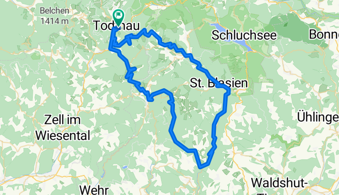
23.7.12 - Todtnau-Bernau-St. Blasien
A cycling route starting in Todtnau, Baden-Württemberg, Germany.
Overview
About this route
- -:--
- Duration
- 83.9 km
- Distance
- 1,697 m
- Ascent
- 1,697 m
- Descent
- ---
- Avg. speed
- ---
- Avg. speed
Route quality
Waytypes & surfaces along the route
Waytypes
Track
31.1 km
(37 %)
Busy road
21.3 km
(25 %)
Surfaces
Paved
38.5 km
(46 %)
Unpaved
28.3 km
(34 %)
Asphalt
34.5 km
(41 %)
Gravel
18.6 km
(22 %)
Continue with Bikemap
Use, edit, or download this cycling route
You would like to ride 23.7.12 - Todtnau-Bernau-St. Blasien or customize it for your own trip? Here is what you can do with this Bikemap route:
Free features
- Save this route as favorite or in collections
- Copy & plan your own version of this route
- Split it into stages to create a multi-day tour
- Sync your route with Garmin or Wahoo
Premium features
Free trial for 3 days, or one-time payment. More about Bikemap Premium.
- Navigate this route on iOS & Android
- Export a GPX / KML file of this route
- Create your custom printout (try it for free)
- Download this route for offline navigation
Discover more Premium features.
Get Bikemap PremiumFrom our community
Other popular routes starting in Todtnau
 Fröhnd_Mi_MTB_Todtnaurunde
- Distance
- 30.9 km
- Ascent
- 972 m
- Descent
- 971 m
- Location
- Todtnau, Baden-Württemberg, Germany
 Feldberg-Herzogenhorn-Runde
- Distance
- 60.5 km
- Ascent
- 1,288 m
- Descent
- 1,286 m
- Location
- Todtnau, Baden-Württemberg, Germany
 1. za. Schwarzwald Nord
- Distance
- 56.9 km
- Ascent
- 1,592 m
- Descent
- 1,593 m
- Location
- Todtnau, Baden-Württemberg, Germany
 Vom Hasenhorn nach Geschwend
- Distance
- 35.1 km
- Ascent
- 656 m
- Descent
- 1,074 m
- Location
- Todtnau, Baden-Württemberg, Germany
 Black Forest Ultra Bike Speed Track 54 Km 1200 HM
- Distance
- 53 km
- Ascent
- 968 m
- Descent
- 1,620 m
- Location
- Todtnau, Baden-Württemberg, Germany
 3. ma. Schwarzwald Centrum West ^Schauinsland^Giesshübel2x^Belchen ^Spitzkopf
- Distance
- 112.3 km
- Ascent
- 2,434 m
- Descent
- 2,433 m
- Location
- Todtnau, Baden-Württemberg, Germany
 Todtnau-Notschrei-Kandel-Feldberg-Todtnau
- Distance
- 125.5 km
- Ascent
- 2,488 m
- Descent
- 2,486 m
- Location
- Todtnau, Baden-Württemberg, Germany
 7. vr. kort. Schwarzwald West ^Giesshübel^Simitz^Blauen
- Distance
- 112.2 km
- Ascent
- 2,670 m
- Descent
- 2,670 m
- Location
- Todtnau, Baden-Württemberg, Germany
Open it in the app