Ruhestein_Hornisgrinde_Seebach
A cycling route starting in Seebach, Baden-Wurttemberg, Germany.
Overview
About this route
Wonderful tour in the Northern Black Forest! Starting point Ruhestein. The route features many viewpoints
- 3 h 31 min
- Duration
- 48.7 km
- Distance
- 1,207 m
- Ascent
- 1,225 m
- Descent
- 13.8 km/h
- Avg. speed
- 1,153 m
- Max. altitude
Route photos
Continue with Bikemap
Use, edit, or download this cycling route
You would like to ride Ruhestein_Hornisgrinde_Seebach or customize it for your own trip? Here is what you can do with this Bikemap route:
Free features
- Save this route as favorite or in collections
- Copy & plan your own version of this route
- Sync your route with Garmin or Wahoo
Premium features
Free trial for 3 days, or one-time payment. More about Bikemap Premium.
- Navigate this route on iOS & Android
- Export a GPX / KML file of this route
- Create your custom printout (try it for free)
- Download this route for offline navigation
Discover more Premium features.
Get Bikemap PremiumFrom our community
Other popular routes starting in Seebach
- Tour Schwarzwald - Hornisgrinde
- Distance
- 63.2 km
- Ascent
- 1,303 m
- Descent
- 1,303 m
- Location
- Seebach, Baden-Wurttemberg, Germany
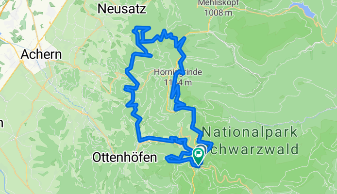
- Ruhestein_Schliffkopf_Zuflucht
- Distance
- 37.7 km
- Ascent
- 746 m
- Descent
- 746 m
- Location
- Seebach, Baden-Wurttemberg, Germany
- Hornisgrinde - Bühl
- Distance
- 26.9 km
- Ascent
- 68 m
- Descent
- 1,089 m
- Location
- Seebach, Baden-Wurttemberg, Germany
- Hornisgrinde - Panoramatour
- Distance
- 42.3 km
- Ascent
- 1,106 m
- Descent
- 1,106 m
- Location
- Seebach, Baden-Wurttemberg, Germany
- Seebach - Gipfeltour auf dem Grindenpfad
- Distance
- 4.8 km
- Ascent
- 181 m
- Descent
- 180 m
- Location
- Seebach, Baden-Wurttemberg, Germany
- Schliffkopf - Hornisgrinde - Schönmünz - Baiersbronn Obertal - Schliffkopf
- Distance
- 54.5 km
- Ascent
- 1,370 m
- Descent
- 1,419 m
- Location
- Seebach, Baden-Wurttemberg, Germany
- B29 Über den Mummelsee auf die Hornisgrinde
- Distance
- 8.3 km
- Ascent
- 302 m
- Descent
- 304 m
- Location
- Seebach, Baden-Wurttemberg, Germany
- Seebach - Seebacher Bergtour
- Distance
- 13.3 km
- Ascent
- 667 m
- Descent
- 678 m
- Location
- Seebach, Baden-Wurttemberg, Germany
Open it in the app