
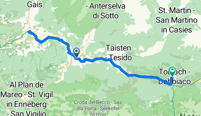
Via Hans Von Perthaler nach Graf Künigl Straße
A cycling route starting in Olang, Trentino-Alto Adige, Italy.
Overview
About this route
- 2 h 31 min
- Duration
- 41.4 km
- Distance
- 841 m
- Ascent
- 655 m
- Descent
- 16.5 km/h
- Avg. speed
- 1,236 m
- Max. altitude

Route quality
Waytypes & surfaces along the route
Waytypes
Track
12.4 km
(30 %)
Cycleway
8.7 km
(21 %)
Surfaces
Paved
30.7 km
(74 %)
Unpaved
10.4 km
(25 %)
Asphalt
30.7 km
(74 %)
Gravel
10.4 km
(25 %)
Undefined
0.4 km
(1 %)
Continue with Bikemap
Use, edit, or download this cycling route
You would like to ride Via Hans Von Perthaler nach Graf Künigl Straße or customize it for your own trip? Here is what you can do with this Bikemap route:
Free features
- Save this route as favorite or in collections
- Copy & plan your own version of this route
- Sync your route with Garmin or Wahoo
Premium features
Free trial for 3 days, or one-time payment. More about Bikemap Premium.
- Navigate this route on iOS & Android
- Export a GPX / KML file of this route
- Create your custom printout (try it for free)
- Download this route for offline navigation
Discover more Premium features.
Get Bikemap PremiumFrom our community
Other popular routes starting in Olang
- Olang - Pieve di Cadore
- Distance
- 77.3 km
- Ascent
- 531 m
- Descent
- 784 m
- Location
- Olang, Trentino-Alto Adige, Italy
 Route nach Via Polo Stegona Marco
- Distance
- 14.8 km
- Ascent
- 48 m
- Descent
- 329 m
- Location
- Olang, Trentino-Alto Adige, Italy
 Staller Sattel
- Distance
- 148.7 km
- Ascent
- 2,518 m
- Descent
- 2,424 m
- Location
- Olang, Trentino-Alto Adige, Italy
 Via Hans Von Perthaler nach Graf Künigl Straße
- Distance
- 41.4 km
- Ascent
- 841 m
- Descent
- 655 m
- Location
- Olang, Trentino-Alto Adige, Italy
 Antholzer Höhentour ab Olang
- Distance
- 37 km
- Ascent
- 1,461 m
- Descent
- 1,181 m
- Location
- Olang, Trentino-Alto Adige, Italy
 Route in Olang
- Distance
- 18.5 km
- Ascent
- 1,143 m
- Descent
- 1,141 m
- Location
- Olang, Trentino-Alto Adige, Italy
 Piazza Floriani nach Via Hans Von Perthaler
- Distance
- 39.8 km
- Ascent
- 658 m
- Descent
- 702 m
- Location
- Olang, Trentino-Alto Adige, Italy
 Via Hans Von Perthaler 8a nach St.Veit
- Distance
- 19.5 km
- Ascent
- 717 m
- Descent
- 236 m
- Location
- Olang, Trentino-Alto Adige, Italy
Open it in the app