
Melli25_T3
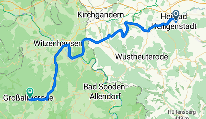
A cycling route starting in Heilbad Heiligenstadt, Thuringia, Germany.
Overview
About this route
Aus den Tiefen des Thüringer Waldes hinab in die Ebene der Vorderrhön, entlang des salzigsten Flusses in Thüringen lädt der Werratal-Radweg zu schönen Stunden ein.
- 2 h 36 min
- Duration
- 45.2 km
- Distance
- 517 m
- Ascent
- 397 m
- Descent
- 17.4 km/h
- Avg. speed
- 387 m
- Max. altitude
Route quality
Waytypes & surfaces along the route
Waytypes
Track
14 km
(31 %)
Path
8.1 km
(18 %)
Surfaces
Paved
33 km
(73 %)
Unpaved
0.5 km
(1 %)
Asphalt
29.8 km
(66 %)
Paved (undefined)
3.2 km
(7 %)
Continue with Bikemap
Use, edit, or download this cycling route
You would like to ride Melli25_T3 or customize it for your own trip? Here is what you can do with this Bikemap route:
Free features
- Save this route as favorite or in collections
- Copy & plan your own version of this route
- Sync your route with Garmin or Wahoo
Premium features
Free trial for 3 days, or one-time payment. More about Bikemap Premium.
- Navigate this route on iOS & Android
- Export a GPX / KML file of this route
- Create your custom printout (try it for free)
- Download this route for offline navigation
Discover more Premium features.
Get Bikemap PremiumFrom our community
Other popular routes starting in Heilbad Heiligenstadt
 Heilbad Heiligenstadt Cycling
- Distance
- 61 km
- Ascent
- 245 m
- Descent
- 333 m
- Location
- Heilbad Heiligenstadt, Thuringia, Germany
 Pedalritter-2010-T4-Heiligenstadt-SZ
- Distance
- 130.6 km
- Ascent
- 664 m
- Descent
- 804 m
- Location
- Heilbad Heiligenstadt, Thuringia, Germany
 Heiligenstadt-Leinefelde_Köhlersgrund-A 38-Wingerode-Leineradweg-Heiligenwstadt
- Distance
- 30.4 km
- Ascent
- 172 m
- Descent
- 172 m
- Location
- Heilbad Heiligenstadt, Thuringia, Germany
 Saisonstart 23 kleine Eic Runde
- Distance
- 42.6 km
- Ascent
- 650 m
- Descent
- 613 m
- Location
- Heilbad Heiligenstadt, Thuringia, Germany
 Melli25_T3
- Distance
- 45.2 km
- Ascent
- 517 m
- Descent
- 397 m
- Location
- Heilbad Heiligenstadt, Thuringia, Germany
 Verbessererte Vers. der Strecke HIG-Geisl.-Heuthen-Werdingshausen-Flinsbg.-u.z.
- Distance
- 28.6 km
- Ascent
- 438 m
- Descent
- 438 m
- Location
- Heilbad Heiligenstadt, Thuringia, Germany
 Leineradweg Heilbad Heiligenstadt - Arenshausen
- Distance
- 15.3 km
- Ascent
- 71 m
- Descent
- 133 m
- Location
- Heilbad Heiligenstadt, Thuringia, Germany
 HIG- Steinheuterr.-Schachtebich-Rohrbg.-Vogelsang- Bischh.-Siemerode- Mengelrode-HIG
- Distance
- 31.4 km
- Ascent
- 289 m
- Descent
- 289 m
- Location
- Heilbad Heiligenstadt, Thuringia, Germany
Open it in the app